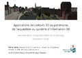
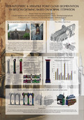
Multiple Uses of a 3D Point Cloud: the Castle of Franchimont (Province of Liège, Belgium)
Luczfalvy Jancsó, Andrea; Jonlet, Benoît; Hallot, Pierre et al.
2017 • In Hayes, James; Ouimet, Christian; Santana Quintero, Mario et al. (Eds.) ISPRS - The International Archives of the Photogrammetry, Remote Sensing and Spatial Information Sciences. 26th International CIPA Symposium – Digital Workflows for Heritage Conservation
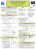
This paper presents the identified obstacles, needs and selected solutions for the study of the m...