2017 • In Hayes, James; Ouimet, Christian; Santana Quintero, Marioet al. (Eds.) ISPRS - The International Archives of the Photogrammetry, Remote Sensing and Spatial Information Sciences. 26th International CIPA Symposium – Digital Workflows for Heritage Conservation
3D digitisation; 3D Point cloud; Building archaeology; Visualisation; Integrated survey; AIS; Archaeological Information System
Abstract :
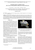
[en] This paper presents the identified obstacles, needs and selected solutions for the study of the medieval castle of Franchimont, located in the province of Liège (Belgium). After taking into account the requirements from all the disciplines at work as well as the problems that would have to be tackled, the creation of a 3D point cloud was decided. This solution would be able to deal with the characteristics and needs of a research involving building archaeology and related fields. The decision was made in order to manage all of the available data and to provide a common working tool for every involved cultural heritage actor. To achieve this, the elaboration of an Archaeological Information System based on 3D point clouds as a common virtual workspace is being taken into consideration.
Disciplines :
Physical, chemical, mathematical & earth Sciences: Multidisciplinary, general & others Archaeology Arts & humanities: Multidisciplinary, general & others
Author, co-author :
Luczfalvy Jancsó, Andrea ; Université de Liège > Département de géographie > Unité de Géomatique - Topographie et géométrologie
Jonlet, Benoît ; Université de Liège > Département de géographie > Unité de Géomatique - Topographie et géométrologie
Hallot, Pierre ; Université de Liège > Département de géographie > Architecture Site Lambert Lombard
Hoffsummer, Patrick ; Université de Liège > Département des sciences historiques > Archéologie médiévale et post-médiévale
Billen, Roland ; Université de Liège > Département de géographie > Unité de Géomatique - Topographie et géométrologie
Language :
English
Title :
Multiple Uses of a 3D Point Cloud: the Castle of Franchimont (Province of Liège, Belgium)
Alternative titles :
[fr] Usages multiples d'un nuage de points 3D : le château de Franchimont (Province de Liège, Belgique)
Publication date :
2017
Event name :
Digital Workflows for Heritage Conservation. CIPA 2017 - 26th International Symposium
Event organizer :
Mario Santana Quintero, Christian Ouimet et Stephen Fai
Event place :
Ottawa, Canada
Event date :
du 28 août 2017 au 1 septembre 2017
Audience :
International
Main work title :
ISPRS - The International Archives of the Photogrammetry, Remote Sensing and Spatial Information Sciences. 26th International CIPA Symposium – Digital Workflows for Heritage Conservation
Alby, E., Point cloud vs drawing on archaeological site (2015) ISPRS - Int. Arch. Photogramm. Remote Sens. Spat, Inf. Sci, pp. 7-11. , XL-5/W7
Arlaud, C., Burnouf, J., Dossier : L'archéologie du bâti médiéval urbain (1993) Nouv. Archéologie, 53-54, pp. 5-69
Boto-Varela, G., Hartmann-Virnich, A., Nussbaum, N., Reveyron, N., Tallon, A., Archéologie du bâti : du mètre au laser (2012) Perspect. Actual. en Hist. L'art 2012, pp. 329-346
Canciani, M., Saccone, M., The use of 3D models in integrate Survey: The church of St. Thomas of villanova in castel gandolfo (2012) ISPRS - Int. Arch. Photogramm. Remote Sens. Spat. Inf. Sci, pp. 591-597. , XXXVIII-5/W16
Cripps, P., Places, people, events and stuff
building blocks for archaeological information systems (2013) Archaeology in the Digital Era, Volume II. E-Papers from the 40th Annual Conference of Computer Applications and Quantitative Methods in Archaeology (CAA) Southampton, pp. 487-497. , 26-29 Mars 2012. Presented at the Archaeology in the Digital Era. CAA 2012, Amsterdam University Press, Amsterdam doi:oai:ARNO:500958
De Kleijn, M., De Hond, R., Martinez-Rubi, O., A 3D spatial data infrastructure for mapping the via appia (2016) Digit. Appl. Archaeol. Cult. Herit, 3, pp. 23-32
Eßer, G., Kanngießer, J., Ganspöck, M., Der Image laserscanner - ein multitalent ! kann der 3D-laserscanner ein konventionelles bauaufmaß ersetzen? (2011) Von Handaufmass Bis High Tech III : Erfassen, Modellieren, Visualisieren. 3D in Der Historischen Bauforschung, pp. 14-25. , Heine, K. (Ed.), Presented at the Von Handaufmass bis High Tech III : Erfassen, modellieren, visualisieren. 3D in der historischen Bauforschung
Interdisziplinäres Kolloquium vom 24.- 27. Februar 2010, von Zabern, Darmstadt
Héno, R., Borel, L., Alby, E., Favre-Brun, A., Archéologie et photogrammétrie : Les nouveaux potentiels (2010) Géomètre, pp. 26-40
Hoffsummer, P., (2016) Le Château de Franchimont à Theux, Carnets Du Patrimoine, , Institut du Patrimoine wallon, Namur
Lilien, A., (2002) La Forteresse de Franchimont : Hypothèse de Restauration des Ruines pour Une Meilleure Perception des Espaces, , Catholic University Leuven. Raymond Lemaire centre for the conservation of historic towns and buildings
Limp, W.F., Measuring the face of the past and facing the measurement (2016) Digital Methods and Remote Sensing in Archaeology, pp. 349-369. , Forte, M. Campana, S. (Eds.), Springer International Publishing, Cham
Luczfalvy Jancsó, A., Jonlet, B., Hallot, P., Poux, F., Hoffsummer, P., Billen, R., CASTLE4D: An archaeological information system based on 3D point clouds (2016) Proceedings of the ARQUEOLÓGICA 2.0 8th International Congress on Archaeology, Computer Graphics, Cultural Heritage And, Innovation, pp. 247-252. , http://dx.doi.org/10.4995/arqueologica8.2016.4210, Lerma, J.L. Cabrelles, M. (Eds.), Universitat Politècnica València, Valencia
McManama-Kearin, K., Forced Focus: A room with a viewshed (2012) L'origine Du Château Médiéval
Actes Du Colloque International de Rindern, pp. 243-247. , Ettel, P. Gaillard, C.C. (Eds.), (Allemagne) 28 Août - 3 Septembre 2010, Château Gaillard : Études de Castellologie Médiévale. Presented at the L'origine du château médiéval, Crahm, Caen
McManama-Kearin, L.K., (2013) The Use of GIS in Determining the Role of Visibility in the Siting of Early Anglo-Norman Stone Castles in Ireland, British Archaeological Reports British Series, , Archaeopress, Oxford
Poux, F., Neuville, R., Hallot, P., Billen, R., Point clouds as an efficient multiscale layered spatial representation (2016) Eurographics Workshop on Urban Data Modelling and Visualisation (2016). Eurographics Workshop on Urban Data Modelling and Visualisation (2016), pp. 31-36. , Biljecki, F. Tourre, V. (Eds
Salvador, I., Vitti, A., Survey, representation and analysis of a war i complex system of surface and underground fortifications in the gresta Valley, Italy (2012) ISPRS - Int. Arch. Photogramm. Remote Sens. Spat. Inf. Sci., pp. 319-325. , XXXVIII-5/W16
Schuller, M., (2002) Building Archaeology, Monuments and Sites, , ICOMOS, München
Wéry, B., (2015) La Modélisation 3D Du Château Fort de Logne à Vieuxville (Ferrières) : Entre Archéologie Et, médiation