Article (Scientific journals)
How Can Remote Sensing Help Monitor Tropical Moist Forest Degradation?—A Systematic Review
Dupuis, Chloé; Lejeune, Philippe; Michez, Adrien et al.
2020In Remote Sensing, 12 (7), p. 1087
Peer Reviewed verified by ORBi
 

Files


Full Text
remotesensing-12-01087.pdf
Publisher postprint (1.94 MB)
Download
Annexes
CD_Table_S1.xlsx
Publisher postprint (128.85 kB)
Download
graphical_abstract-01.jpg
Publisher postprint (622.11 kB)
Download

All documents in ORBi are protected by a user license.

Send to


Details


Keywords :
tropical moist forest; forest degradation; remote sensing; forest degradation metrics; forest resilience; forest structure; forest composition; forest regeneration
Abstract :
[en] In the context of the climate and biodiversity crisis facing our planet, tropical forests playing a key role in global carbon flux and containing over half of Earth’s species are important to preserve. They are today threatened by deforestation but also by forest degradation, which is more difficult to 
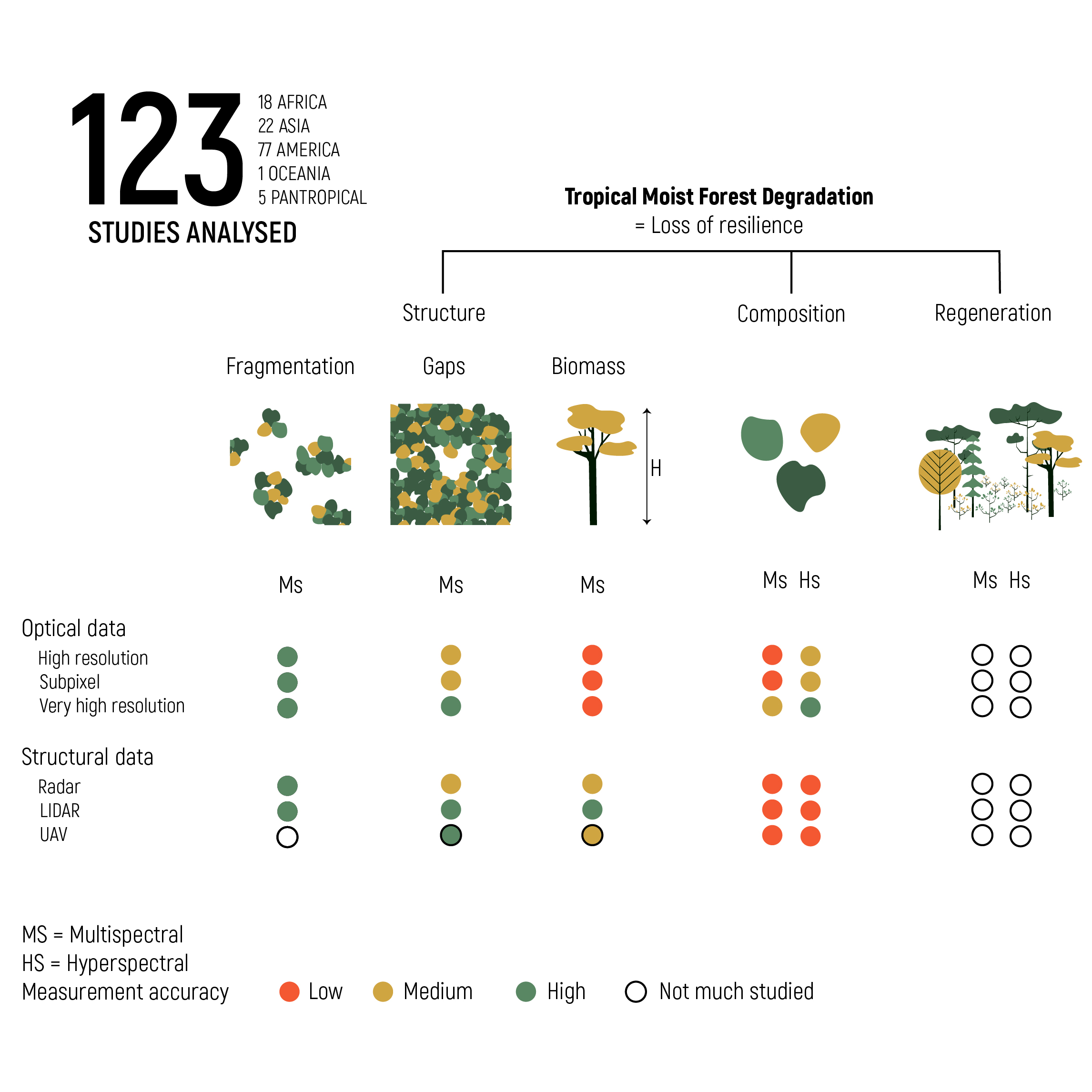
study. Here, we performed a systematic review of studies on moist tropical forest degradation using remote sensing and fitting indicators of forest resilience to perturbations. Geographical repartition, spatial extent and temporal evolution were analyzed. Indicators of compositional, structural and regeneration criteria were noted as well as remote sensing indices and metrics used. Tropical moist forest degradation is not extensively studied especially in the Congo basin and in southeast Asia. Forest structure (i.e., canopy gaps, fragmentation and biomass) is the most widely and easily measured criteria with remote sensing, while composition and regeneration are more difficult to characterize. Mixing LiDAR/Radar and optical data shows good potential as well as very high-resolution satellite data. The awaited GEDI and BIOMASS satellites data will fill the actual gap to a large extent and provide accurate structural information. LiDAR and unmanned aerial vehicles (UAVs) form a good bridge between field and satellite data. While the performance of the LiDAR is no longer to be demonstrated, particular attention should be brought to the UAV that shows great potential and could be more easily used by local communities and stakeholders.
Research center :
TERRA Research Centre - TERRA
Disciplines :
Environmental sciences & ecology
Engineering, computing & technology: Multidisciplinary, general & others
Author, co-author :
Dupuis, Chloé ;  Université de Liège - ULiège > Département GxABT > Gestion des ressources forestières et des milieux naturels
Lejeune, Philippe ;  Université de Liège - ULiège > Département GxABT > Gestion des ressources forestières et des milieux naturels
Michez, Adrien  ;  Université de Liège - ULiège > Département GxABT > Gestion des ressources forestières et des milieux naturels
Fayolle, Adeline  ;  Université de Liège - ULiège > Département GxABT > Gestion des ressources forestières et des milieux naturels
Language :
English
Title :
How Can Remote Sensing Help Monitor Tropical Moist Forest Degradation?—A Systematic Review
Publication date :
28 March 2020
Journal title :
Remote Sensing
eISSN :
2072-4292
Publisher :
Multidisciplinary Digital Publishing Institute (MDPI), Basel, Switzerland
Special issue title :
Forest Degradation Monitoring
Volume :
12
Issue :
7
Pages :
1087
Peer reviewed :
Peer Reviewed verified by ORBi
Available on ORBi :
since 28 March 2020

Statistics


Number of views
180 (22 by ULiège)
Number of downloads
349 (18 by ULiège)

Scopus citations®
 
36
Scopus citations®
without self-citations
36
OpenCitations
 
25

Bibliography


Similar publications


Contact ORBi