  | Degré, A.* , Guillaume, B.* , Michez, A.* , Bonaventure, N., Leyh, E., di Maggio, L., & Rabouli, S. (2024). Modélisation hydrologique du bassin versant de la Vesdre - projet ModRec. https://orbi.uliege.be/handle/2268/314437 * These authors have contributed equally to this work. |
 | Linchant, J., Lejeune, P., Quevauvillers, S., Vermeulen, C., Brostaux, Y., Lhoest, S., & Michez, A. (17 March 2023). Evaluation of an Innovative Rosette Flight Plan Design for Wildlife Aerial Surveys with UAS. Drones, 7 (3), 208. doi:10.3390/drones7030208  Peer Reviewed verified by ORBi Peer Reviewed verified by ORBi |
  | Müllerová, J., Bartaloš, T., Gago, X., Kent, R., Michez, A., Mokroš, M., Mücher, S., & Paulus, G. (2023). Vegetation mapping and monitoring by unmanned aerial systems (UAS)—current state and perspectives. In Unmanned Aerial Systems for Monitoring Soil, Vegetation, and Riverine Environments. Elsevier. doi:10.1016/B978-0-323-85283-8.00008-4 Editorial reviewed |
 | Bolyn, C., Lejeune, P., Michez, A., & Latte, N. (October 2022). Mapping tree species proportions from satellite imagery using spectral–spatial deep learning. Remote Sensing of Environment, 280, 113205. doi:10.1016/j.rse.2022.113205 Peer Reviewed verified by ORBi |
 | Rodríguez‐González, P. M., Abraham, E., Aguiar, F., Andreoli, A., Baležentienė, L., Berisha, N., Bernez, I., Bruen, M., Bruno, D., Camporeale, C., Čarni, A., Chilikova‐Lubomirova, M., Corenblit, D., Ćušterevska, R., Doody, T., England, J., Evette, A., Francis, R., Garófano‐Gómez, V., ... Dufour, S. (2022). Bringing the margin to the focus: 10 challenges for riparian vegetation science and management. WIREs Water. doi:10.1002/wat2.1604 Peer reviewed |
 | Lejeune, P., Michez, A., Perin, J., Gilles, A., Latte, N., Ligot, G., Lisein, J., & Claessens, H. (2022). L’ÉPICÉA WALLON : ÉTAT DE LA RESSOURCE EN 2021. Silva Belgica. |
 | Georges, B., Michez, A., Piégay, H., Huylenbroeck, L., Lejeune, P., & Brostaux, Y. (2021). Which environmental factors control extreme thermal events in rivers? A multi-scale approach (Wallonia, Belgium). PeerJ. doi:10.7717/peerj.12494 Peer Reviewed verified by ORBi |
 | Georges, B., Michez, A., Latte, N., Lejeune, P., & Brostaux, Y. (2021). Water stream heating dynamics around extreme temperature events: An innovative method combining GAM and differential equations. Journal of Hydrology. doi:10.1016/j.jhydrol.2021.126600 Peer Reviewed verified by ORBi |
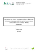
 | De Coster, A., Desteucq, O., Englebert, B., Georges, B., Claessens, H., & Michez, A. (2021). ANALYSE DES PROGRAMMES D’ACTIONS PARIS ÉLABORÉS PAR LES GESTIONNAIRES DE COURS D’EAU POUR LA PÉRIODE 2022-2027. Forêt.Nature, (158). |
 | Huylenbroeck, L., Latte, N., Lejeune, P., Georges, B., Claessens, H., & Michez, A. (20 March 2021). What Factors Shape Spatial Distribution of Biomass in Riparian Forests? Insights from a LiDAR Survey over a Large Area. Forests, 12 (371). doi:10.3390/f12030371 Peer Reviewed verified by ORBi |
 | Bindelle, J., Da Silva Neto, G. F., Kokah, E. U., de Faccio Carvalho, P., & Michez, A. (2021). Drone-based remote sensing of sward structure and biomass for precision grazing: state of the art and future challenges. In Proceedings of the 21st Symposium of the European Grassland Federation. Peer reviewed |
 | Michez, A., Broset, S., & Lejeune, P. (2021). Ears in the Sky: Potential of Drones for the Bioacoustic Monitoring of Birds and Bats. Drones, 5 (1 9). doi:10.3390/drones5010009 Peer Reviewed verified by ORBi |
 | Fonseca, A., Ugille, J.-P., Michez, A., Rodríguez-González, P. M., Duarte, G., Ferreira, M. T., & Fernandes, M. R. (2021). Assessing the Connectivity of Riparian Forests across a Gradient of Human Disturbance: The Potential of Copernicus “Riparian Zones” in Two Hydroregions. Forests, 12 (6 674). doi:10.3390/f12060674 Peer Reviewed verified by ORBi |
 | Müllerová, J., Gago, X., Bučas, M., Company, J., Estrany, J., Fortesa, J., Manfreda, S., Michez, A., Mokroš, M., Paulus, G., Tiškus, E., Tsiafouli, M. A., & Kent, R. (2021). Characterizing vegetation complexity with unmanned aerial systems (UAS) – A framework and synthesis. Ecological Indicators, 131, 108156. doi:10.1016/j.ecolind.2021.108156 Peer Reviewed verified by ORBi |
 | Baralle, G., Marchal, A. F. J., Lejeune, P., & Michez, A. (2021). Individual Identification of Cheetah (Acinonyx jubatus) Based on Close-Range Remote Sensing: First Steps of a New Monitoring Technique. Remote Sensing, 13 (6 1090). doi:10.3390/rs13061090 Peer Reviewed verified by ORBi |
 | Georges, B., Claessens, H., De Coster, A., Desteucq, O., Englebert, B., Huylenbroeck, L., & Michez, A. (2020). Une approche intégrée et sectorisée de la gestion des cours d’eau wallons : les PARIS. Forêt.Nature, (157), 18-28. |
 | Lejeune, P., & Michez, A. (2020). Introduction aux géotraitements dans l’environnement R. (ULiège - Université de Liège). |
 | Michez, A. (13 October 2020). Présentation du système de suivi régional des ripisylves en Wallonie, et des transferts de connaissances associés [Paper presentation]. Séminaire "Comment améliorer la gestion de nos ripisylves ? Quelles pratiques adopter face aux nouveaux enjeux ?", Orléans, France. |
 | Michez, A., Huylenbroeck, L., Bolyn, C., Latte, N., Bauwens, S., & Lejeune, P. (01 October 2020). Can regional aerial images from orthophoto surveys produce high quality photogrammetric Canopy Height Model? A single tree approach in Western Europe. International Journal of Applied Earth Observation and Geoinformation, 92, 102190. doi:10.1016/j.jag.2020.102190 Peer Reviewed verified by ORBi |
 | Huylenbroeck, L.* , Laslier, M.* , Dufour, S., Georges, B., Lejeune, P., & Michez, A. (01 August 2020). Using remote sensing to characterize riparian vegetation: a review of available tools and perspectives for managers. Journal of Environmental Management, 267. doi:10.1016/j.jenvman.2020.110652 Peer Reviewed verified by ORBi* These authors have contributed equally to this work. |
 | Georges, B., Brostaux, Y., Claessens, H., Degré, A., Huylenbroeck, L., Lejeune, P., Piégay, H., & Michez, A. (01 July 2020). Can water level stations be used for thermal assessment in aquatic ecosystem? River Research and Applications, 36 (6), 960-973. doi:10.1002/rra.3520 Peer Reviewed verified by ORBi |
 | Latte, N., Gaucher, P., Bolyn, C., Lejeune, P., & Michez, A. (16 April 2020). Upscaling UAS Paradigm to UltraLight Aircrafts: A Low-Cost Multi-Sensors System for Large Scale Aerial Photogrammetry. Remote Sensing, 12 (8). doi:10.3390/rs12081265 Peer Reviewed verified by ORBi |
 | Dupuis, C., Lejeune, P., Michez, A., & Fayolle, A. (28 March 2020). How Can Remote Sensing Help Monitor Tropical Moist Forest Degradation?—A Systematic Review. Remote Sensing, 12 (7), 1087. doi:10.3390/rs12071087 Peer Reviewed verified by ORBi |
 | Georges, B., Piégay, H., Lejeune, P., Brostaux, Y., & Michez, A. (31 January 2020). Investigating stream water temperature in southern Belgium : environmental drivers and potential impact on a thermal sensitive species (Salmo trutta fario) [Poster presentation]. 25th National Symposium for Applied Biological Sciences (NSABS), Gembloux, Belgium. |
 | Michez, A., Lejeune, P., David, K., Sébastien, D., Christian, D., & Bindelle, J. (2020). Can Low-Cost Unmanned Aerial Systems Describe the Forage Quality Heterogeneity? Insight from a Timothy Pasture Case Study in Southern Belgium. Remote Sensing, 12 (10 1650). doi:10.3390/rs12101650 Peer Reviewed verified by ORBi |
 | Huylenbroeck, L., Michez, A., Claessens, H., & Desteucq, O. (2020). Le « Guide de gestion des ripisylves » mis à jour. Forêt.Nature, 155 (Avril - juin 2020), 61-69. |
 | Georges, B., Rollin, X., Gailliez, S., & Michez, A. (2019). Suivi de la température des cours d’eau wallons : potentiels et contraintes du réseau Aqualim. Forêt.Nature, (153), 42-53. |
 | Bebronne, R., Michez, A., Leemans, V., Dumont, B., Vermeulen, P., & Mercatoris, B. (2019). Characterisation of fungal diseases on winter wheat crop using proximal and remote multispectral imaging. In Precision agriculture ’19 (pp. 255-261). Wageningen, Netherlands: Wageningen Academic Publishers. doi:10.3920/978-90-8686-888-9_31 Peer reviewed |
Huylenbroeck, L., Michez, A., & Lejeune, P. (2019). Supporting river management with UAV’s in the Provinces of Liège and Luxembourg [Paper presentation]. ID2MOVE - Séminaire académique sur les systèmes autonomes, Nivelles, Belgium. |
 | Michez, A., Lejeune, P., Bauwens, S., Herinaina, A. A. L., Blaise, Y., Castro Muñoz, E., Lebeau, F., & Bindelle, J. (2019). Mapping and Monitoring of Biomass and Grazing in Pasture with an Unmanned Aerial System. Remote Sensing, 11 (5 473). doi:10.3390/rs11050473 Peer Reviewed verified by ORBi |
 | Huylenbroeck, L., Michez, A., & Claessens, H. (2019). Guide de gestion des ripisylves. Namur, Belgium: Service Public Wallonie. |
 | Bolyn, C., Lejeune, P., Michez, A., & Latte, N. (2019). Automated Classification of Trees outside Forest for Supporting Operational Management in Rural Landscapes. Remote Sensing, 11 (10), 1146. doi:10.3390/rs11101146 Peer Reviewed verified by ORBi |
 | Michez, A., Bauwens, S., Brostaux, Y., Hiel, M.-P., Garré, S., Lejeune, P., & Dumont, B. (13 November 2018). How far can consumer grade UAV RGB imagery describe crop production? A 3D and multi-temporal modelling approach applied to Zea mays. Remote Sensing, 10 (11), 1798. doi:10.3390/rs10111798 Peer Reviewed verified by ORBi |
 | Piégay, H., Michez, A., Raepple, B., Stella, J., & Wawrzyniak, V. (18 October 2018). Riparian characterization from remote sensing in a multiple scale perspectives. A few examples [Paper presentation]. Riparian Summit: Confluence to Influence, UC Davis Conference Center, United States. |
 | Huylenbroeck, L., Georges, B., Claessens, H., Lejeune, P., & Michez, A. (07 June 2018). Estimation du volume de bois des forêts riveraines afin d’enappuyer la gestion : Approche par télédétection sur un linéaire étendu (230 km) [Paper presentation]. IS Rivers 2018, Lyon, France. |
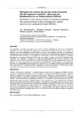
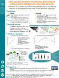 | Georges, B., Hervé, P., Huylenbroeck, L., Lejeune, P., Brostaux, Y., & Michez, A. (June 2018). Using gauging network for regional monitoring of stream water temperature (Wallonia, Belgium) [Poster presentation]. International conference I.S.Rivers 2018 - integrative sciences and sustainable development of rivers, Lyon, France. |
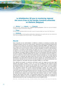 | Michez, A., Lejeune, P., Claessens, H., Piégay, H., & Desteucq, O. (2018). La télédétection 3D pour le monitoring régional des cours d’eau et des bandes riveraines associées en Wallonie (Belgique). In A. Vivier, L. Breton, S. Grivel, ... G. Melun, Avancées, apports et perspectives de la télédétection pour la caractérisation physique des corridors fluviaux - Actes de la journée technique (pp. 18-27). |
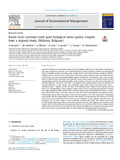 | Brogna, D., Dufrêne, M., Michez, A., Latli, A., Jacobs, S., Vincke, C., & Dendoncker, N. (2018). Forest cover correlates with good biological water quality. Insights from a regional study (Wallonia, Belgium). Journal of Environmental Management, 211, 9 - 21. doi:10.1016/j.jenvman.2018.01.017 Peer Reviewed verified by ORBi |
 | Bolyn, C., Michez, A., Gaucher, P., Lejeune, P., & Bonnet, S. (2018). Forest mapping and species composition using supervised per pixel classification of Sentinel-2 imagery. Biotechnologie, Agronomie, Société et Environnement, 22 (3), 16. doi:10.25518/1780-4507.16524 Peer Reviewed verified by ORBi |
 | Michez, A., Piégay, H., Lejeune, P., & Claessens, H. (01 November 2017). Multi-temporal monitoring of a regional riparian buffer network (>12,000 km) with LiDAR and photogrammetric point clouds. Journal of Environmental Management, 202 (2), 424-436. doi:10.1016/j.jenvman.2017.02.034 Peer Reviewed verified by ORBi |
 | Michez, A., Bauwens, S., Heinesch, B., Manise, T., Glesener, M., Mercatoris, B., Dumont, B., & Lejeune, P. (20 October 2017). Upscaling winter wheat above-ground biomass measurements using multispectral imagery and 3D data from unmanned aerial vehicle [Poster presentation]. ICOS BELGIUM Science Conference 2017, Gembloux, Belgium. |
 | Brogna, D., Michez, A., Jacobs, S., Dufrêne, M., Vincke, C., & Dendoncker, N. (01 March 2017). Linking Forest Cover to Water Quality: A Multivariate Analysis of Large Monitoring Datasets. Water, 9 (3), 176. doi:10.3390/w9030176 Peer Reviewed verified by ORBi |
 | Michez, A., Bauwens, S., Bonnet, S., & Lejeune, P. (2016). Caractérisation des forêts à l’aide de la technologie lidar. In N. Baghdadi & M. Zribi, Observation des Surfaces Continentales par Télédétection: Agriculture et Forêt. Londres, United Kingdom: ISTE. Peer reviewed |
 | Michez, A. (2016). Caractérisation multi-échelle des bandes riveraines des cours d’eau wallons par télédétection active et passive [Doctoral thesis, ULiège - Université de Liège]. ORBi-University of Liège. https://orbi.uliege.be/handle/2268/202415 |
 | Michez, A., Morelle, K., Lehaire, F., Widar, J., Authelet, M., Vermeulen, C., & Lejeune, P. (11 October 2016). Use of Unmanned Aerial System to assess wildlife (Sus scrofa) damage to crops (Zea mays). Journal of Unmanned Vehicle Systems, 4(4), 266-275. doi:10.1139/juvs-2016-0014 Peer reviewed |
 | Michez, A., Bauwens, S., Bonnet, S., & Lejeune, P. (2016). Characterization of Forests with LiDAR Technology. In N. Baghdadi & M. Zribi, Land Surface Remote Sensing in Agriculture and Forest (1ère édition, pp. 331-362). Amsterdam, Netherlands: Elsevier. doi:10.1016/B978-1-78548-103-1.50008-X Peer reviewed |
 | Michez, A., Piégay, H., Desteucq, O., Lejeune, P., & Claessens, H. (10 June 2016). Apport des nuages de points LiDAR et photogrammétriques pour le monitoring de 12000 km de cours d’eau en Wallonie (Belgique) [Paper presentation]. Journée Technique "Avancées, apports et perspectives de la télédétection pour la caractérisation physique des corridors fluviaux", Paris, France. |
 | Michez, A., Piégay, H., Lisein, J., Claessens, H., & Lejeune, P. (February 2016). Mapping of riparian invasive species with supervised classification of Unmanned Aerial System (UAS) imagery. International Journal of Applied Earth Observation and Geoinformation, 44. doi:10.1016/j.jag.2015.06.014 Peer Reviewed verified by ORBi |
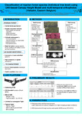
 | Michez, A., Piégay, H., Lisein, J., Claessens, H., & Lejeune, P. (2016). Classification of riparian forest species and health condition using multi-temporal and hyperspatial imagery from unmanned aerial system. Environmental Monitoring and Assessment, 188 (3). doi:10.1007/s10661-015-4996-2 Peer Reviewed verified by ORBi |
 | Michez, A. (11 December 2015). Utilisation des drones pour la caractérisation de la végétation riveraine des cours d'eau : Cartographie des plantes invasives Composition spécifique et état sanitaire [Paper presentation]. Séminaire d'échanges sur le thème de l'utilisation du drone dans le suivi environnemental, Rennes, France. |
 | Lisein, J., Michez, A., Claessens, H., & Lejeune, P. (24 November 2015). Discrimination of deciduous tree species from time series of unmanned aerial system imagery. PLoS ONE, 10 (11). doi:10.1371/journal.pone.0141006 Peer Reviewed verified by ORBi |
 | Michez, A., Henrotay, F., Mengal, C., & Claessens, H. (2015). Intégration d'un monitoring des secteurs de cours d'eau dans le cadre des Programmes d'Actions sur les Rivières par une approche Intégrée et Sectorisée (PARIS) - Projet Imageau 3. ULg - Université de Liège. https://orbi.uliege.be/handle/2268/199917 |
| Dedry, L., De Thier, O., Perin, J., Michez, A., Bonnet, S., & Lejeune, P. (2015). ForEstimator. |
 | Dedry, L., De Thier, O., Perin, J., Michez, A., Bonnet, S., & Lejeune, P. (2015). ForEstimator : un nouvel outil cartographique pour mieux connaître la forêt wallonne. Forêt.Nature, (135), 40-46. |
 | Dedry, L., Dethier, O., Perin, J., Michez, A., Bonnet, S., & Lejeune, P. (2015). FORESTIMATOR: un plugin QGIS d’estimation de la hauteur dominante et du Site Index de peuplements résineux à partir de LiDAR aérien. Revue Française de Photogrammétrie et de Télédétection, 211-212. doi:10.52638/rfpt.2015.550 Peer Reviewed verified by ORBi |
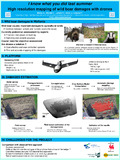 | Michez, A., Morelle, K., Lehaire, F., Widar, J., & Lejeune, P. (01 September 2014). I know what you did last summer - High resolution mapping of wild boar damages with drones [Poster presentation]. 10th International Symposium on Wild Boar and Other Suids, Velenje, Slovenia. |
 | Lisein, J., Michez, A., & Lejeune, P. (26 June 2014). Discrimination des essences forestières via des collections d'images multidates acquises par drone [Poster presentation]. Colloque scientifique francophone Drones et moyens légers aéroportés d'observation, Montpellier, France. |
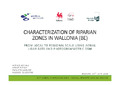 | Michez, A., Piégay, H., Lejeune, P., & Claessens, H. (16 June 2014). Characterization of riparian zones in wallonia (belgium) [Paper presentation]. 34th EARSeL Symposium, Varsovie, Poland. |
 | Michez, A., Henrotay, F., & Claessens, H. (2014). Exploitation des données aéroportées (LiDAR aérien et drone) dans le cadre des programmes d'actions sur les rivières par une approche intégrée et sectorisée (PARIS) – projet "Imageau 2". ULg - Université de Liège. https://orbi.uliege.be/handle/2268/197955 |
 | Michez, A., Piégay, H., Lejeune, P., & Claessens, H. (February 2014). Characterization of riparian zones in wallonia (belgium) from local to regional scale using aerial lidar data and photogrammetric DSM. EARSeL eProceedings, 13 (2). doi:10.12760/01-2014-2-06 Peer reviewed |
 | Michez, A., Doucet, J.-L., Dendocker, N., Bouché, P., & Vermeulen, C. (01 December 2013). Preliminary description of the diet of Hippopotamus amphibius L. in Loango National Park (Gabon). Biotechnologie, Agronomie, Société et Environnement, 17 (4), 580-583. Peer Reviewed verified by ORBi |
 | Lisein, J., Michez, A., & Lejeune, P. (20 November 2013). Using unmanned aerial systems for the monitoring of Belgium forests: discrimination of tree species based on time series of airborne images [Paper presentation]. Belgian Earth Observation Days 2013. |
 | Michez, A., Lisein, J., Geerts, C., Henrotay, F., Monseur, A., Claessens, H., & Lejeune, P. (15 October 2013). Utilisation des drones comme outil de suivi de travaux de restauration : génération de séries temporelles d'orthomosaïques à très haute résolution et de modèles numériques de surface [Poster presentation]. La restauration hydromorphologique des cours d’eau : premiers enseignements du projet LIFE WALPHY, Namur, Belgium. |
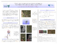
 | Michez, A., Lisein, J., Toromanoff, F., Bonnet, S., Lejeune, P., & Claessens, H. (09 September 2013). Classification of riparian forest species (individual tree level) using UAV-based Canopy Height Model and multi-temporal orthophotos (Vielsalm, Eastern Belgium) [Poster presentation]. Workshop on UAV-based Remote Sensing Methods for Monitoring Vegetation, Cologne, Germany. |
 | Lisein, J., Michez, A., Bonnet, S., & Lejeune, P. (09 September 2013). Crown area allometries for surveying blossoming wild cherry with unmanned aerial system (UAS) [Poster presentation]. Workshop on UAV-basedRemote SensingMethodsforMonitoring Vegetation. |
 | Michez, A., Henrotay, F., & Claessens, H. (2013). POTENTIALITES DE L'OUTIL "ANALYSE D'IMAGES" DANS LE CADRE DE LA GESTION INTEGREE DES COURS D'EAU WALLONS : PROJET IMAGEAU. Ulg. https://orbi.uliege.be/handle/2268/161438 |
 | Bonnet, S., Toromanoff, F., Bauwens, S., Michez, A., Dedry, L., & Lejeune, P. (2013). Principes de base de la télédétection et ses potentialités comme outil de caractérisation de la ressource forestière – II. LiDAR aérien. Forêt Wallonne, (124), 28-41. |
 | Michez, A. (2013). Apports de la télédétection pour la gestion des cours d’eau : cas des données LiDAR et drone (projet Imageau) [Paper presentation]. Réunion thématique "Hydromorphologie", Douai, France. |
 | Michez, A., Piégay, H., Toromanoff, F., Brogna, D., Bonnet, S., Lejeune, P., & Claessens, H. (2013). LiDAR derived ecological integrity indicators for riparian zones: Application to the Houille river in Southern Belgium/Northern France. Ecological Indicators, 34 (0), 627 - 640. doi:10.1016/j.ecolind.2013.06.024 Peer Reviewed verified by ORBi |
 | Michez, A. (2012). Méthodologie définie pour le découpage physique des cours d’eau en secteurs [Paper presentation]. Les cours d’eau évolution législative et lien avec le foncier, Gembloux, Belgium. |
 | Michez, A., & Vermeulen, C. (2010). Entre conflit, compétition, et braconnage : la problématique de la conservation de l’hippopotame en forêt dense humide. Parcs et Réserves, 65 (2), 12-19. |
 | Michez, A. (2006). Etude de la population d’hippopotames (Hippopotamus amphibius L.) de la rivière Mouena Mouele au Parc National du Loango-Sud (Gabon) [Master’s dissertation, ULiège - Université de Liège]. ORBi-University of Liège. https://orbi.uliege.be/handle/2268/150645 |
