[en] An engineering geological map can be defined as a geological map with a generalized representation of all the components of a geological environment which are strongly required for spatial planning, design, construction and maintenance of civil engineering buildings.
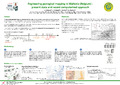
In Wallonia (Belgium) 24 engineering geological maps have been developed between the 70s and the 90s at 1/5,000 or 1/10,000 scale covering some areas of the most industrialized and urbanized cities (Liège, Charleroi and Mons). They were based on soil and subsoil data point (boring, drilling, penetration test, geophysical test, outcrop. . . ). Some displayed data present the depth (with isoheights) or the thickness (with isopachs) of the different subsoil layers up to about 50 m depth. Information about geomechanical properties of each subsoil layer,useful for engineers and urban planners, is also synthesized. However, these maps were built up only on paper and progressively needed to be updated with new soil and subsoil data. The Public Service of Wallonia and the University of Liège have recently initiated a study to evaluate the feasibility to develop engineering geological mapping with a computerized approach. Numerous and various data (about soil and subsoil) are stored into a georelational database (the geotechnical database – using Access, Microsoft®). All the data are geographically referenced. The database is linked to a GIS project (using ArcGIS, ESRI®). Both the database and GIS project consist of a powerful tool for spatial data management and analysis. This approach involves a methodology using interpolation methods to update the previous maps and to extent the coverage to new areas. The location (x, y, z) of each subsoil layer is then computed from data point. The geomechanical data of these layers are synthesized in an explanatory booklet joined to maps.
Disciplines :
Geological, petroleum & mining engineering
Author, co-author :
Delvoie, Simon ; Université de Liège - ULiège > Département ArGEnCo > Géomécanique et géologie de l'ingénieur
Radu, Jean-Pol ; Université de Liège - ULiège > Département ArGEnCo > Géomécanique et géologie de l'ingénieur
Ruthy, Ingrid ; Université de Liège - ULiège > Département ArGEnCo > Hydrogéologie & Géologie de l'environnement
Charlier, Robert ; Université de Liège - ULiège > Département ArGEnCo > Géomécanique et géologie de l'ingénieur
Language :
English
Title :
Engineering geological mapping in Wallonia (Belgium) : present state and recent computerized approach