[en] Nowadays, image processing and GIS tools are more accessible and available to all. Most of diachronical or
historical studies use the image geometric correction with several documents like old maps, plans or aerial
photographs. They are usually based on low-order polynomial equation to perfom these kinds of simplistic uses.
Most of commercial softwares provide us a total or by ground control points RMSE but they don’t offer a
overview of the spatial error distribution. More this does not guarantee that its significance for the other points of
the image.
Do not consider these errors can lead to erroneous observations and misinterpretations like historical moving
streams or bank erosion rate.
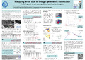
Using a least square adjustment (LSA), allow to recalculate the transformation equation from the pairs of
control points coordinates. Assuming that residuals are spatially auto-correlated, we can build error vectors whose
direction and magnitude symbolize the error at each point of the image.
By another way, LSA manage the precision during transformation process by using a stochastic model in addition of the mathematical model during the transformation. This gives us variance on parameters of the transformation.
Knowing the precision of all elements and variance/covariance matrix on transformation parameters, we apply variance propagation on the model. As an output, we obtain confidence ellipses on each transformed points, thus a spatial distribution of error for the entire image. Moreover, this leads us to determine statistically if observed movement are significant or not.
The represent error is a complex problem that cannot be solved with a quick fix. In this work, we present an interesting example of using well-known topographic methods to solve image processing problems.
Disciplines :
Earth sciences & physical geography
Author, co-author :
Hallot, Eric ; Université de Liège - ULiège > Département de géographie > Hydrographie et géomorphologie fluviatile
Cornet, Yves ; Université de Liège - ULiège > Département de géographie > Unité de Géomatique - Télédétection et photogrammétrie
Hallot, Pierre ; Université de Liège - ULiège > Département de géographie > Unité de Géomatique - Topographie et géométrologie
Language :
English
Title :
Mapping error due to image geometric correction.
Publication date :
April 2012
Number of pages :
2x1m
Event name :
EGU General Assembly, Vienne, Autriche, avril 2012,