Abstract :
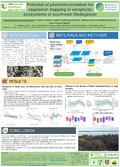
[en] Arid ecosystems, particularly in the southwest of Madagascar, present significant challenges for vegetation mapping due to their structural and physiological complexity. These ecosystems, which are highly impacted by deforestation, require accurate and timely monitoring to support effective conservation and management efforts. This study aims to develop a robust methodology for generating maps of wood cover (WC), height of vegetation (H95), tree cover (TC), and shrub cover (SC) for 2022 in the arid ecosystems of southwest Madagascar. We combine remote sensing data, field inventories, and photointerpretation to improve the precision of vegetation cover estimates in these complex environments. To generate the H95 map, field measurements of vegetation height were combined with satellite-derived variables. A Random Forest model was applied to establish relationships between explanatory variables and field data, allowing for the prediction of H95 across the study area. The WC map was generated using forest inventory data and photointerpretation, while the TC and SC maps were derived from the H95 and WC maps, respectively. Data from optical and radar satellites were integrated, and field inventories from 2023 were used for model validation. The results demonstrate that the integration of radar and optical data, validated with 2023 field inventories, provides accurate vegetation cover estimates. While slight underestimation of shrub cover was observed due to temporal differences between predicted and ground-truth data, the maps produced outperform global reference datasets such as GFCC, GFW, and CGLS-LC100. High-resolution drone data is expected to further improve map accuracy in future studies.