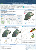
[en] Accurately representing water flows at a regional scale is essential for hydrological assessments, particularly in the context of extreme weather events such as floods. The increasing frequency of highintensity rainfall events, driven by climate change, poses a growing threat to both human settlements and agricultural lands [1]. The devastating floods of 2021 in Wallonia and neighboring regions highlighted the urgent need for improved runoff flood risk assessment. In response, the Walloon Public Service (SPW) has launched the HYDRAXES project (in collaboration with UCLouvain).
Research Center/Unit :
TERRA Research Centre. Echanges Eau - Sol - Plantes - ULiège
Disciplines :
Environmental sciences & ecology Life sciences: Multidisciplinary, general & others
Author, co-author :
Herpoel, Matthieu ; Université de Liège - ULiège > TERRA Research Centre
Baert, Pierre ; Université de Liège - ULiège > Département GxABT > Echanges Eau - Sol - Plantes
Degré, Aurore ; Université de Liège - ULiège > TERRA Research Centre > Echanges Eau - Sol - Plantes
Language :
English
Title :
Advancing runoff flood risk mapping: Spatialized peak flows along concentrated flow paths in Wallonia (HYDRAXES)