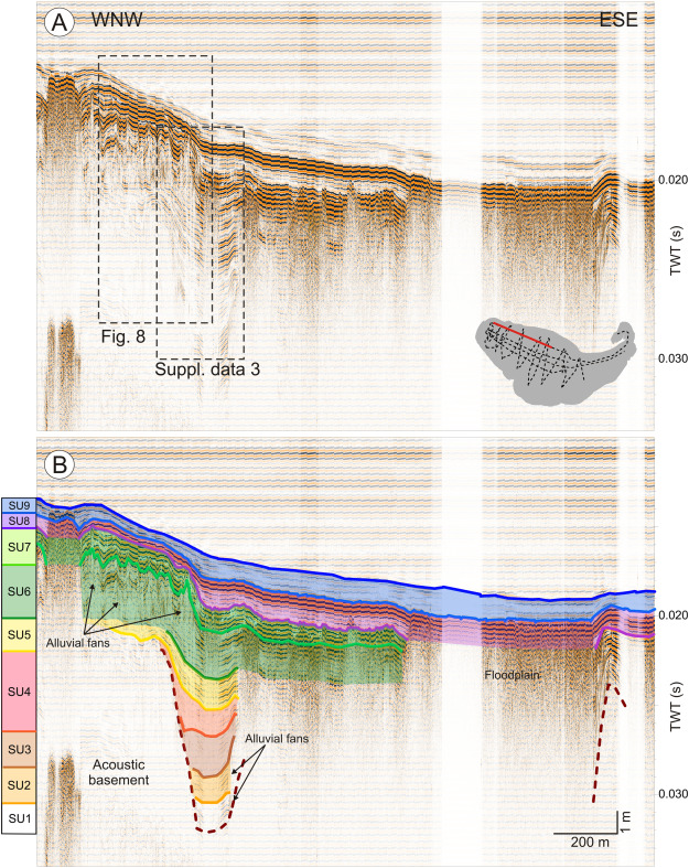
Suppl. data 2. WNW-ESE seismic profile (A) and its interpretation (B). The seismic profile (YAM01) is dominated by the acoustic blanking in the east-south-east. Close-up of this seismic reflection profiles are shown in Fig. 8 and Suppl. Data 3.
Suppl. data 3. A. Close-up of the WNW-ESE seismic reflection profile YAM01 crossing the central part of the lake. B. Interpretations of WNW-ESE seismic reflection profile. The seismic reflection profile images a series of lens-shaped chaotic seismic facies interpreted as alluvial fans in SU1 (D1b), SU2 (D2b) and SU6 (D6b).
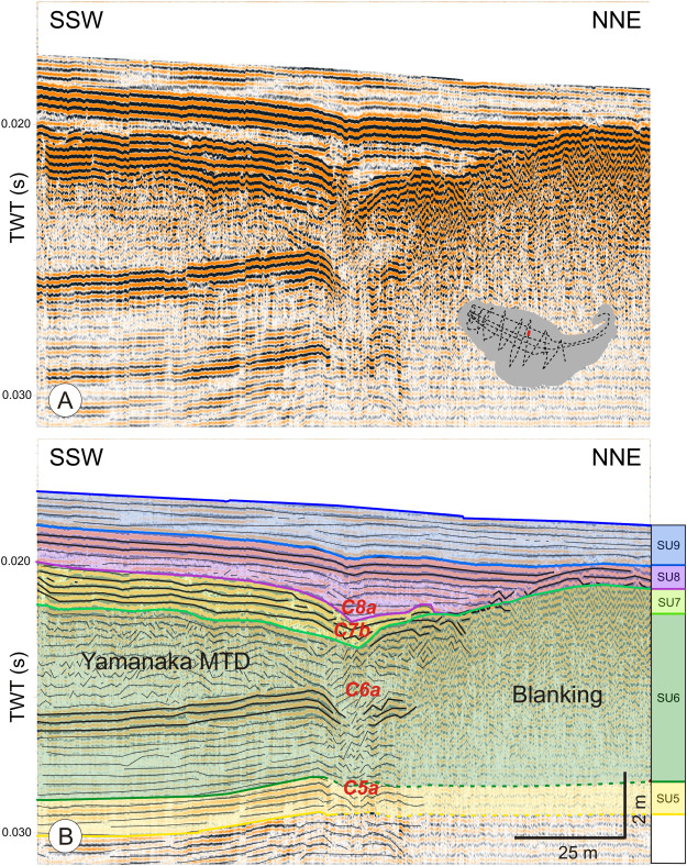
Suppl. data 4. A. SSW-NNE seismic reflection profile of the extremity of the central basin (YAM11). B. Interpretation of SSW-NNE seismic reflection profile with. This profile evidences a succession of incision in the sedimentary infill (C5a, C6a, C7b and C8a) attributed to the east inlet river. The emplacement of Yamanaka MTD (imaged by chaotic semi-transparent seismic facies - SF3) buried the east inlet river during SU6.
lake level fluctuations; Mt. Fuji; depositional history
Abstract :
[en] High-resolution seismic profiles, combined with the integration of published drilling data, provide a detailed paleoenvironmental history of Lake Yamanaka (Fuji Five Lakes, Japan). This study presents a detailed analysis of the different depositional stages of the area currently occupied by Lake Yamanaka (floodplain wetland, river and lake). From ca. 5500 cal yr BP to ca. 5050 cal yr BP, the Yamanaka basin was occupied by floodplain wetlands. During that period, the landscape was very stable and erosion on northeastern flank of Mt. Fuji was relatively limited. From ca. 5050 cal yr BP to ca. 3050 cal yr BP, the water level increased and the floodplain wetlands became a lake. From ca. 3050 cal yr BP to ca. 2050 cal yr BP, the water level progressively decreased, leading to a reduction in lake extent. During this lowering of the lake's water level, a 1 km2 mass-transport deposit modified the physiography of the lake floor. From ca. 2050 cal yr BP to ca. 1050 cal yr BP, the lake disappeared and a river flowing towards the northwest occupied the depression. Ponds occupied morphological lows formed by mass transport deposits. From ca. 1050 cal yr BP to the present day, the lake water level rose again, connecting the ponds with the main lake. Since then, the lake water level has continued to rise to the current level. Lake water level fluctuations are the results of several factors that could be interconnected: (i) changes in precipitation rates; (ii) margin destabilization (the Yamanaka mass-transport deposit), (iii) changes in river inlets and therefore variation in water supplies, (iv) volcanic eruptions (scoria fall-out and lava flows) and (v) changes in vegetation cover. This study highlights the importance of coupling sediment cores and high-resolution seismic reflection profiling to identify lateral variation and modification of sedimentary inputs through time.
Adhikari, D.P., Koshimizu, S., Uchiyama, T., Variation in particle size distribution in the core sediment of Lake Yamanaka, northeastern foot of Mt. Fuji and its paleoenvironmental significance. Proceeding of the 15th Symposium on Geo-environments and Geo-Technics, 2005, 191–196.
Bronk Ramsey, C., Deposition models for chronological records. Quat. Sci. Rev. 27:1–2 (2008), 42–60.
Endo, K., Taba, Y., Miyaji, N., Nakai, N., Shinohara, T., Miyahara, T., Kosugi, M., Geomorphological study on the formation of Lake Yamanaka, along the foot of Fuji Volcano. Proceeding of the Institute of Natural Sciences, Nihon University (Applied Earth Sciences), 27, 1992, 33–36 (In Japanese with abstract in English).
Geospatial Information Authority of Japan. 1963. 1:10,000 scale bathymetric map “Lake Yamanaka”.
Heiri, O., Lotter, A.F., Lemcke, G., Loss on ignition as a method for estimating organic and carbonate content in sediments: reproducibility and comparability of results. J. Paleolimnol. 25 (2001), 101–110.
Hirabayashi, K., Yoshizawa, K., Yoshida, N., Kazama, F., Progress of eutrophication and change of chironomid fauna in Lake Yamanakako, Japan. Limnology 5 (2004), 47–53.
Koshimizu, S., Uchiyama, T., Geological outline of the borehole cores from Fuji-Five Lakes surrounding Mt. Fuji, Central Japan. Daishiki 34 (2002), 9–18.
Koshimizu, S., Uchiyama, T., Yamamoto, G., Volcanic history of Mt. Fuji recorded in borehole cores from Fuji Five Lakes surrounding Mt. Fuji. Fuji. Aramaki, S., Fujii, T., Nakada, S., Miyaji, N., (eds.) Fuji Volcano, Yamanashi Institute of Environmental Sciences, 2007, 365–374 (in Japanese with English abstract).
Kosugi, M., Ikeda, M., Eguchi, S., Origin and evolution of Lake Yamanaka, Fuji Volcanic Region, Central Japan - (2) record on the natural history of environments during Last 2500 years, based on multiple fossil analyses. Proceeding of the Institute of Natural Sciences, Nihon University (Applied Earth Sciences), 27, 1992, 37–44 (In Japanese with abstract in English).
Kosugi, M., Ikeda, M., Endo, K., Environmental history during the last 2500 years recorded in sediments of Lake Yamanaka, based on the fundamental study of transportation and sedimentation of pollen grains. Mem. Geol. Soc. Jpn.: Lakes-Origin, Environ. Geol. 39 (1993), 41–52 (In Japanese with abstract in English).
Last, W.M., Smol, J.P., (eds.) Tracking Environmental Change Using Lake Sediments. Volume 1: Basin Analysis, Coring, and Chronological Techniques, 2001, Kluwer Academic Publishers, Dordrecht (548 pp).
Liu, J., Saito, Y., Wang, H., Yang, Z., Nakashima, R., Sedimentary evolution of the Holocene subaqueous clinoform off the Shandong Peninsula in the Yellow Sea. Mar. Geol. 236 (2007), 165–187.
Machida, H., Tephrochronological study of volcano Fuji and adjacent areas. J. Geogr. (Chigakuzasshi) 73 (1964), 337–350 (in Japanese with English abstract).
Mitchum, J.R.M., Vail, P.R., Sangree, J.B., Seismic stratigraphy and global changes of sea level, part 6: stratigraphic interpretation of seismic reflection patterns in depositional sequences. Payton, C.E., (eds.) Seismic Stratigraphy Applications to Hydrocarbon Exploration, American Association of Petroleum Geologists Memoir 26, 1977, 117–133.
Miyaji, N., History of younger Fuji volcano. J. Geol. Soc. Jpn. 94 (1988), 433–452 (in Japanese with English abstract).
Miyaji, N., Eruptive history, eruption rate and scale of eruptions for the Fuji Volcano during the last 11,000 years, Fuji volcano. Aramaki, S., Fujii, T., Nakada, S., Miyaji, N., (eds.) Fuji Volcano, 2007, Yamanashi Institute of Environmental Sciences, 79–95 (in Japanese with English abstract).
Moernaut, J., De Batist, M., Frontal emplacement and mobility of sublacustrine landslides: results from morphometric and seismostratigraphic analysis. Mar. Geol. 285 (2011), 29–45.
Nakano, S., Takada, A., Ishizuka, Y., Suzuki, Y., Chiba, T., Arai, K., Kobayashi, M., Tajima, Y., Eruption ages of younger-stage lava flows and older stage pyroclastic cones on the North Eastern foot of Fuji Volcano, Japan. Bull. Geol. Surv. Jpn 57:11/12 (2007), 387–407.
Ozaki, M., Makimoto, H., Sugiyama, Y., Mimura, K., Sakai, A., Kubo, K., Kato, H., Komazawa, M., Hiroshima, T., Sudo, S., 2002. Geological map of Japan 1: 200 000, Kofu. Geological Survey of Japan, AIST, Tsukuba, Japan (in Japanese with English abstract).
Pirmez, C., Pratson, L.F., Steckler, M.S., Clinoform development by advection-diffusion of suspended sediment: modeling and comparison to natural systems. J. Geophys. Res. 103 (1998), 24141–24157.
Reimer, P.J., Bard, E., Bayliss, A., Beck, J.W., Blackwell, P.G., Bronk Ramsey, C., Buck, C.E., Cheng, H., Edwards, R.L., Friedrich, M., Grootes, P.M., Guilderson, T.P., Haflidason, H., Hajdas, I., Hatté C., Heaton, T.J., Homann, D.L., Hogg, A.G., Hughen, K.A., Kaiser, K.F., Kromer, B., Manning, S.W., Niu, M., Reimer, R.W., Richards, D.A., Scott, E.M., Southon, J.R., Staff, R. A, Turney, C.S.M., van der Plicht, J., IntCal13 and Marine13 radiocarbon age calibration curves 0–50,000 years cal BP. Radiocarbon 55 (2013), 1869–1887.
Schnellmann, M., Anselmetti, F.S., Giardini, D., McKenzie, J.A., Mass movement-induced fold-and-thrust belt structures in unconsolidated sediments in Lake Lucerne (Switzerland). Sedimentology 52 (2005), 271–289.
Shimada, T., Kashiwaya, K., Hyodo, M., Masuzawa, T., Hydro-environmental fluctuation in a lake catchment system during the late Holocene inferred from Lake Yogo sediments. Trans. Jpn. Geomorphol. 23 (2002), 415–431 (in Japanese with English abstract and captions).
Smith, V.C., Staff, R.A., Blockley, S.P.E., Bronk Ramsey, C., Nakagawa, T., Mark, D.F., Takemura, K., Danhara, T., Suigetsu 2006 Project Members, Identification and correlation of visible tephras in the Lake Suigetsu SG06 sedimentary archive, Japan: chronostratigraphic markers for synchronising of east Asian/West Pacific palaeoclimatic records across the last 150 ka. Quat. Sci. Rev. 67 (2013), 121–137.
Taba, Y., Kosugi, M., Endo, K., Miyaji, N., Origin and evolution of Lake Yamanaka, Fuji Volcanic Region, Central Japan - (1) stratigraphy and paleoenvironments based on the borehole core in the lake. Proceeding of the Institute of Natural Sciences, Nihon University (Applied Earth Sciences), 25, 1990, 39–44 (In Japanese with abstract in English).
Taba, Y., Seino, H., Endo, H., Komori, J., Subaqueous topography by acoustic survey in the Westernmost part of Lake Yamanaka. Proceeding of the Institute of Natural Sciences, Nihon University (Geosystem Sciences), 34, 1999, 121–128 (In Japanese with abstract in English).
Takada, A., Ishizuka, Y., Nakano, S., Yamamoto, T., Kobayashi, M., Suzuki, Y., Characteristic and evolution inferred from eruptive fissures of Fuji volcano, Japan. Aramaki, S., Fujii, T., Nakada, S., Miyaji, N., (eds.) Fuji Volcano, 2007, Yamanashi Institute of Environmental Sciences, 183–202 (in Japanese with English abstract).
Takada, A., Yamamoto, T., Ishizuka, Y., Nakano, S., Geological Map of Fuji Volcano, 2nd Edition (Ver.1). 2016, Geological Survey of Japan, AIST, Tsukuba, Japan.
Tani, S., Kitagawa, H., Hong, W., Park, J.H., Sung, K.S., Park, G., Age determination of the Kawagodaira volcanic eruption in Japan by 14C wiggle-matching. Proceedings of the 21st International Radiocarbon Conference, 55 (2–3), 2013, 748–752.
Uesugi, Y., Ikeda, K., Suda, A., Yanagisawa, T., Okamoto, M., Suzuki, S., On the Takamarubi lavas erupted from the northeastern flank of Fuji Volcano. Bull. Assoc. Kanto Quat. Res. 19 (1995), 3–21 (in Japanese).
Van Daele, M., Versteeg, W., Pino, M., Urrutia, R., De Batist, M., Widespread deformation of basin-plain sediments in Aysén Fjord (Chile) due to impact by earthquake-triggered, onshore-generated mass movements. Mar. Geol. 337 (2013), 67–79.
Wada, Y., Chosen Kodai Kansoku Kiroku Chousa Houkoku (aReport on Past Observational Records in Korea). 1916, Observatory at Governor of Korea's Office, Seoul (in Japanese).
Yamamoto, T., Takada, A., Ishizuka, Y., Nakano, S., Chronology of the products of Fuji volcano based on new radiometric carbon ages. Bull. Geol. Surv. Jpn 50 (2005), 53–70 (in Japanese with English abstract).
Yamamoto, S., Uchiyama, T., Miyairi, Y., Yokoyama, Y., Volcanic and environmental influences of Mt. Fuji on the δ13C of terrestrially-derived n-alkanoic acids in sediment from Lake Yamanaka, Central Japan. Org. Geochem. 119:C (2018), 50–58.
YIES, YIES Research Report 8. Yamanashi Prefecture, Japan: Yamanashi Institute of Environmental Sciences. 2004 (106 pp (in Japanese with English captions)).
Yoshizawa, K., Koshimizu, S., Uchiyama, T., Environmental change based on diatom assemblages from Lake Yamanaka at the northern foot of Mt. Fuji, Central Japan. Rep. Res. Edu. Ctr. Inlandwat. Environ. 2 (2004), 105–110.
Zhou, Y., Wenninger, J., Yang, Z., Yin, L., Huang, J., Hou, L., Wang, X., Zhang, D., Uhlenbrook, S., Groundwater–surface water interactions, vegetation dependencies and implications for water resources management in the semi-arid Hailiutu River catchment, China – a synthesis. Hydrol. Earth Syst. Sci. 17 (2013), 2435–2447.
