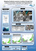
[en] Over the last decades, the interest in mapping Posidonia oceanica beds has increased along with the improvement of the equipment’s precision of data acquisition. In Calvi Bay (Corsica, France) the meadows cover an area of about 5 km² and are found at a depth ranging from 3 m to 37 m. The availability of three distinct datasets for 1997, 2002 and 2010 allowed to assess changes in the patchiness of the meadows in the bay and to investigate evolution of maps precision through a surface analysis via GIS software. Thus, three maps were elaborated combining aerial photographs and side scan sonar images. The meadows percentage of cover through time was assessed using four bathymetric sections: 0-10 m, 11-20 m, 21-30 m and 31-40 m.
Differences in the patchiness of P. oceanica meadows between 1997 and 2010 appear to be moderate (less than 3 %) in the sections 0-10 m and 11-20 m and then greatly increase with depth: 24 % at 21-30 m and 39 % at 31-40 m. This amazing regression seems hardly natural and unlikely given the slight quantity of human activities that can cause damages on the P. oceanica meadows of the Calvi Bay. These results are likely to be mainly due to the improvement of precision and resolution of the aerial photographs (5 m in 1997, 0.8 m in 2002 and 0.5 m in 2010) and sonar images (5 m in 1997, 3 m in 2002 and 0.5 m in 2010). An issue of habitat determination (human vs instrumental) linked with the method adopted for mapping can also cause differences in the percentage of cover.
Given the different accuracy among the three maps, the real regression and fragmentation of P. oceanica meadows could be hardly assessed. However, in several areas where the human activities are important, a clear regression or even a disappearance of the meadows has been observed. It is obvious that the last maps are more accurate than the previous ones and, thus, the former can be used for management purpose as well as for study on the patchiness; however, they still keep uncertainty no matter which method is used to create them.