Abstract :
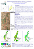
[en] The Kou watershed is a geographical space having important water resources, whose are used between: drinking water supply of Bobo-Dioulasso city (Burkina-Faso’s second most important city) and surrounding localities; agriculture through very important irrigated surfaces; industry; fauna and flora preservation, through a minimal sanitary debit guaranteed. Since some decades, one observes more and more increased pressure on Kou water resources. From an agricultural point of view, a comparative visual observation of irrigated surfaces during the years 1980 and during years 2000 shows an increase of surfaces. It would be then appropriate to establish a potential of irrigation of the set of available water resources in order to estimate maximal irrigable surfaces by water resources. Thus, this study has for goal the evaluation of Kou watershed irrigated zones surface, with the help of remote sensing. In order to facilitate irrigated zones detection, the study will focused on the period between January and June, where all cultures are irrigated with Kou watershed surface water and/or groundwater. The chosen methodology is images classification in order to extract irrigated zones surface. We had for this study a set of images and various data: Landsat-4 TM, Landsat-5 TM, Landsat-7 ETM+, SPOT 5, aerial views, agro meteorological data, cartographic data (GIS), data investigation reports, etc. Because of images various origins, we conducted images pretreatment that essentially consisted in image reflectance calibration. This operation appears to be indispensable when working with images from coming different sensors. Classification methods that we used are: a maximum likelihood classification, then a decision tree classification applied to images for which vegetation index (NDVI) has been calculated. The later classification method has been introduced in order to permit a better discrimination between natural vegetation and crops which can often react in similar spectral ranges. This method is based on threshold detection of vegetation classes. Classification methods used allowed us to estimate until a certain point irrigated surfaces, without having, however, a finer information. With 30 m spatial resolution images covering a survey zone with "reduced" to "mean" agricultural lands size, it is sometimes enough difficult to discern natural vegetation pixels from crop pixels. So, we should have considered mixed classes of pixels that strongly skewed our final results. The overall accuracy of our classifications are between 70% and 90%, with Kappa coefficients between 0.4 and 0.85. These Kappa coefficients our results between "tolerable" and "good". However, our evaluations seem to be near enough of those gotten by the means of hydro agricultural inventories led on the same zone. The committed mistakes remain in an interval of +/-20%.