
  | Benabdelouahab, T. (2015). Using remote sensing (optical and radar) and modeling to support the irrigation management of cereals in a semi-arid region: a case study of the Tadla irrigated perimeter in Morocco [Doctoral thesis, ULiège - Université de Liège]. ORBi-University of Liège. https://orbi.uliege.be/handle/2268/189385 |
  | Benabdelouahab, T., Balaghi, R., Hadria, R., Lionboui, H., Minet, J., & Tychon, B. (30 July 2015). Monitoring surface water content using visible and short-wave infrared SPOT-5 data of wheat plots in irrigated semi-arid regions. International Journal of Remote Sensing, 36 (15), 4018-4036. doi:10.1080/01431161.2015.1072650  Peer Reviewed verified by ORBi Peer Reviewed verified by ORBi |
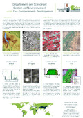 | Wellens, J., Lang, M., Benabdelouahab, T., Denis, A., Tychon, B., Barke, M. (Other coll.), Bouezmarni, M. (Other coll.), Debbaut, V. (Other coll.), Diouf, A. (Other coll.), Durgun, O. (Other coll.), El Jarroudi, M. (Other coll.), Garba, I. (Other coll.), Jacquemin, I. (Other coll.), Minet, J. (Other coll.), Ozer, P. (Other coll.), Sallah, H. (Other coll.), & Sossey Alaoui, K. (Other coll.). (2015). unité: Eau-Environnement-Développement (ULg Campus Arlon): la télédétection au service de l'agriculture. |
 | Benabdelouahab, T., Balaghi, R., Lionboui, H., Hadria, R., & Tychon, B. (28 May 2014). Mapping of vegetation water content using Shortwave Infrared SPOT5 data to monitor irrigation in semi-arid regions [Paper presentation]. Water ressources valuation in arid and semi arid areas, BENIMELLAL, Morocco. |
 | Benabdelouahab, T., Balaghi, R., Barbier, C., Amediaz, R., Noury, H., & Tychon, B. (06 February 2013). Application de la télédétection optique et RADAR pour contribuer à une gestion hydrique efficiente de la céréaliculture des périmètres irrigués au Maroc : Cas du périmètre irrigué du Tadla [Paper presentation]. La télédétection spatiale & la modélisation au service du développement agricole, BENIMELLAL, Morocco. |