
  | Bonnet, S. (2018). Very High Resolution & 3D Remote Sensing Data for Supporting Forestry in Wallonia. What Resolution? What Scale? What Purpose? [Doctoral thesis, ULiège - Université de Liège]. ORBi-University of Liège. https://orbi.uliege.be/handle/2268/225801 |
 | Bolyn, C., Michez, A., Gaucher, P., Lejeune, P., & Bonnet, S. (2018). Forest mapping and species composition using supervised per pixel classification of Sentinel-2 imagery. Biotechnologie, Agronomie, Société et Environnement, 22 (3), 16. doi:10.25518/1780-4507.16524  Peer Reviewed verified by ORBi Peer Reviewed verified by ORBi |
  | Bonnet, S., Lisein, J., & Lejeune, P. (14 June 2017). Comparison of UAS photogrammetric products for tree detection and characterization of coniferous stands. International Journal of Remote Sensing, 38 (19), 5310-5337. doi:10.1080/01431161.2017.1338839 Peer Reviewed verified by ORBi |
 | Michez, A., Bauwens, S., Bonnet, S., & Lejeune, P. (2016). Caractérisation des forêts à l’aide de la technologie lidar. In N. Baghdadi & M. Zribi, Observation des Surfaces Continentales par Télédétection: Agriculture et Forêt. Londres, United Kingdom: ISTE. Peer reviewed |
 | Michez, A., Bauwens, S., Bonnet, S., & Lejeune, P. (2016). Characterization of Forests with LiDAR Technology. In N. Baghdadi & M. Zribi, Land Surface Remote Sensing in Agriculture and Forest (1ère édition, pp. 331-362). Amsterdam, Netherlands: Elsevier. doi:10.1016/B978-1-78548-103-1.50008-X Peer reviewed |
 | Dedry, L., De Thier, O., Perin, J., Michez, A., Bonnet, S., & Lejeune, P. (2015). ForEstimator. |
 | Latte, N., Beeckman, H., Bauwens, S., Bonnet, S., & Lejeune, P. (April 2015). A novel procedure to measure shrinkage-free tree-rings from very large wood samples combining photogrammetry, high-resolution image processing, and GIS tools. Dendrochronologia, 34, 24-28. doi:10.1016/j.dendro.2015.03.002 Peer Reviewed verified by ORBi |
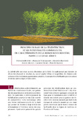
 | Dedry, L., De Thier, O., Perin, J., Michez, A., Bonnet, S., & Lejeune, P. (2015). ForEstimator : un nouvel outil cartographique pour mieux connaître la forêt wallonne. Forêt.Nature, (135), 40-46. |
 | Bonnet, S., Gaulton, R., Lehaire, F., & Lejeune, P. (2015). Canopy Gap Mapping from Airborne Laser Scanning: An Assessment of the Positional and Geometrical Accuracy. Remote Sensing, 7, 11267-11294. doi:10.3390/rs70911267 Peer Reviewed verified by ORBi |
 | Lisein, J., Bonnet, S., Lejeune, P., & Pierrot-Deseilligny, M. (19 June 2014). Modélisation de la canopée forestière par photogrammétrie depuis des images acquises par drone. Revue Française de Photogrammétrie et de Télédétection, 206, 45-54. Peer Reviewed verified by ORBi |
 | Dedry, L., Bonnet, S., Perin, J., & Lejeune, P. (09 April 2014). Applications du LiDAR à la caractérisation dendrométrique de peuplements résineux (Epicéa, Douglas) [Paper presentation]. Journées CAQSIS 2014, Gembloux, Belgium. |
 | Bonnet, S., Dedry, L., Bauwens, S., De Jaegere, T., & Lejeune, P. (2014). Quantifier la ressource forestière grâce au Lidar, quelques applications concrètes. Forêt Wallonne, (129), 42-43. |
Bonnet, S., Dedry, L., Bauwens, S., De Jaegere, T., & Lejeune, P. (2014). Quantifier la ressource forestière grâce au LiDAR - Quelques applications concrètes [Paper presentation]. Journée de transfert chercheurs - gestionnaires. Colloque de restitution de l'Accord-Cadre de Recherche et Vulgarisation forestières, Wépion, Belgium. |
 | Latte, N., Bauwens, S., Bonnet, S., Lejeune, P., & Fayolle, A. (17 January 2014). Dendrochronological analysis of large tropical trees: a new approach combining photogrammetry, image processing and GIS tools [Paper presentation]. 9th International Conference on Dendrochronology, Melbourne (Convention and Exhibition Centre), Australia. |
 | Lisein, J., Pierrot-Deseilligny, M., Bonnet, S., & Lejeune, P. (06 November 2013). A Photogrammetric Workflow for the Creation of a Forest Canopy Height Model from Small Unmanned Aerial System Imagery. Forests, 4. doi:10.3390/f4040922 Peer Reviewed verified by ORBi |
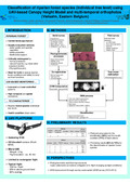 | Michez, A., Lisein, J., Toromanoff, F., Bonnet, S., Lejeune, P., & Claessens, H. (09 September 2013). Classification of riparian forest species (individual tree level) using UAV-based Canopy Height Model and multi-temporal orthophotos (Vielsalm, Eastern Belgium) [Poster presentation]. Workshop on UAV-based Remote Sensing Methods for Monitoring Vegetation, Cologne, Germany. |
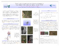 | Lisein, J., Michez, A., Bonnet, S., & Lejeune, P. (09 September 2013). Crown area allometries for surveying blossoming wild cherry with unmanned aerial system (UAS) [Poster presentation]. Workshop on UAV-basedRemote SensingMethodsforMonitoring Vegetation. |
 | Bonnet, S., Toromanoff, F., Bauwens, S., Michez, A., Dedry, L., & Lejeune, P. (2013). Principes de base de la télédétection et ses potentialités comme outil de caractérisation de la ressource forestière – II. LiDAR aérien. Forêt Wallonne, (124), 28-41. |
Bonnet, S. (30 May 2013). La forêt vue du ciel ou comment quantifier la ressource forestière par LiDAR [Paper presentation]. First Research Speed Dating Day. |
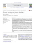 | Michez, A., Piégay, H., Toromanoff, F., Brogna, D., Bonnet, S., Lejeune, P., & Claessens, H. (2013). LiDAR derived ecological integrity indicators for riparian zones: Application to the Houille river in Southern Belgium/Northern France. Ecological Indicators, 34 (0), 627 - 640. doi:10.1016/j.ecolind.2013.06.024 Peer Reviewed verified by ORBi |
Lisein, J., Bonnet, S., & Lejeune, P. (12 September 2012). Creation of a Canopy Height Model from mini-UAV Imagery [Poster presentation]. ForestSAT 2012 | Promoting science-based applications of remote sensing & other spatial data in forested systems, Corvallis, Oregon, United States. |
Bonnet, S., Brostaux, Y., Claessens, H., & Lejeune, P. (September 2012). Diagnosing structure and composition typologies in uneven-aged broad-leaved forests: a comparison of classification methods [Poster presentation]. Silvilaser 2012. |
Bonnet, S., Bauwens, S., Lehaire, F., Ligot, G., & Lejeune, P. (September 2012). The detection and characterization of broad-leaved forest canopy gaps: a regeneration perspective [Poster presentation]. Silvilaser 2012. |
 | Frederickx, C., Verheggen, F., Bonnet, S., & Haubruge, E. (2012). Recensement de Calliphora vicina R.-D., Calliphora vomitoria L. et de Cynomya mortuorum L. (Diptères : Calliphoridae) dans les collections entomologiques des étudiants de Gembloux Agro-Bio Tech sur la période 1995-2009. Entomologie Faunistique, 64 (3), 57-62. Peer Reviewed verified by ORBi |
 | Fourneau, F., Bonnet, S., Toromanoff, F., & Lejeune, P. (2012). Les outils cartographiques open source au service de la gestion des forêts et des milieux naturels. Forêt Wallonne, (118), 14-22. |
 | Bonnet, S., Toromanoff, F., Fourneau, F., & Lejeune, P. (2011). Principes de base de la télédétection et ses potentialités comme outil de caractérisation de la ressource forestière. I. Images aériennes et satellitaires. Forêt Wallonne, (114), 45-56. |
 | Dekeirsschieter, J., Verheggen, F., Bonnet, S., & Haubruge, E. (2011). Recensement des Silphidae dans les collections d'étudiants de Gembloux Agro-Bio Tech sur la période 2001-2010. Entomologie Faunistique, 64 (1), 15-21. Peer Reviewed verified by ORBi |
 | Bonnet, S., Brogna, D., Piron, J., Poncelet, N., Lejeune, P. (Ed.), & Cornet, Y. (Ed.). (2010). Télédétection spatiale de l'occupation du Sol en Wallonie. (Rapport final). Uliège-GRFMN/Géomatique. https://orbi.uliege.be/handle/2268/219974 |
 | Bonnet, S., Gheysen, T., & Lejeune, P. (2010). QGIS, une alternative open source à ArcGIS? |
 | Desclée, B., Bemelmans, V., Bonnet, S., Lejeune, P., & Van der Zande, D. (October 2009). Airborne LiDAR forest inventory: from research to operational applications [Paper presentation]. Luxembourg Earth Observation Day - Remote sensing research and application in Environmental Sciences, Bourglinster, Luxembourg. |
 | Bonnet, S., & Lejeune, P. (29 June 2009). Un Modèle Numérique de Canopée pour l’estimation de la hauteur dominante des peuplements résineux en Région wallonne. |
 | Bonnet, S. (2009). Un modèle numérique de canopée pour l'estimation de la hauteur dominante des peuplements résineux en Région wallonne. Forêt Wallonne, (98), 53-59. |
Bonnet, S. (2007). Contribution à l’évaluation des restaurations du complexe de landes humides et landes tourbeuses du Plateau de Saint-Hubert par l’étude des états de conservation et l’étude des banques de graines [Master’s dissertation, ULiège. GxABT - Liège Université. Gembloux Agro-Bio Tech]. ORBi-University of Liège. https://orbi.uliege.be/handle/2268/115932 |