[en] Hydrologic similarities between catchments can be of use in the context of overland flood and mud flow hazards management. In Wallonia, upstream micro-catchments were mapped for each runoff concentration axis. The outlets of these catchments are considered at the point where water reaches the permanent river stream. No less than 145 547 micro catchments were mapped in Wallonia (16900 km²). Their area varies between 1 and 1233 ha (mean area: 7.8 ha). A data base was built up to synthesize their major characteristics like e.g. area, shape and mean slope. No clear classification appeared.
At this stage, it became obvious that the major components of these catchments had to be handled simultaneously from a hydrological point of view in order to produce a clear classification.
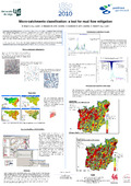
The main hydrologic significant data are available in Wallonia: the digital soil map at 1/20 000 scale, the DTM (raster file of 10 meters resolution), digital land use at 1/10 000 scale and spatial statistics for rain (IDF curves for each commune). A hydrologic model was developed using the python programming language in the ArcGis 9.3 environment. This model is based on the NRCS – USDA method. Rain abstraction is calculated on the basis of a CN (curve number) which integrates the soil type, the land use and the slope. Water transfer is computed using a convolution based on triangular unit hydrogrammes. This calculation includes the concentration time which integrates the catchment morphology (shape and slope) and the land use (roughness). The MUSLE equation is also computed in order to handle the sediment problem.
The results consist in a full project hydrograph, peak flow value, flood water volume and sediment quantification in response to a project rainfall. The CN and MUSLE semi-empirical methods are validated at larger scale in Wallonia but have still to demonstrate their efficiency at the micro-catchment scale. Nevertheless, the aforementioned variables can be considered as integration factors of the whole hydrological context of the micro-catchments. It allows us to build advice on overland flow and mud flow mitigation at watershed scale. This approach can also be of help to compare ungauged micro-catchments between each other and possibly transpose the soil conservation practices from a site to another.