[en] Medium-scale traveling ionospheric disturbances (MSTIDs) are the most recurrent type of ionospheric irregularities at mid-latitudes but also occur in low-latitude regions. Whether they are due to the propagation of atmospheric gravity waves originating from the lower atmosphere or related to sporadic E layers, their harmonic signature is a common feature that allows them to be easily identified.
MSTIDs have been extensively studied and characterized during the last two decades, mainly using GNSS measurements, ground-based all-sky imagers, radars or ionosondes. However, only few studies aimed to describe their vertical structure using remote sensing observations from space, which is helpful to understand their propagation and their dissipation processes.
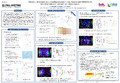
NASA’s TIMED mission was launched in December 2001 on a 74° inclination orbit at an altitude of 625 km, which allowed covering both low and high-latitude regions. The Global Ultraviolet Imager (GUVI) instrument aimed at remotely sense, among others, the ionospheric ion and electron densities. GUVI performed disk observations and limb scans in five FUV wavelength channels, making it an ideal tool to characterize the vertical structure of the ionosphere as well as to contextualize the study.
The purpose of this work is to use GUVI limb scans to characterize MSTIDs preliminary detected by GNSS before December 2007, until the limb scanning mode failed. We first select a few MSTID cases during maximum background conditions of the Total Electron Content (TEC) computed by GNSS ground stations. Then, coincidental GUVI limb scans of the OI-135.6 nm emission are analyzed to characterize the vertical structure of the MSTIDs. The comparison is completed by the analysis of ionosonde profiles collected in the vicinity of the region where the MSTIDs have been previously detected by GNSS and GUVI.
Disciplines :
Earth sciences & physical geography Space science, astronomy & astrophysics
Author, co-author :
Wautelet, Gilles ; Université de Liège - ULiège > Département d'astrophys., géophysique et océanographie (AGO) > Labo de physique atmosphérique et planétaire (LPAP)
Hubert, Benoît ; Université de Liège - ULiège > Département d'astrophys., géophysique et océanographie (AGO) > Labo de physique atmosphérique et planétaire (LPAP)
Gérard, Jean-Claude ; Université de Liège - ULiège > Département d'astrophys., géophysique et océanographie (AGO) > Département d'astrophys., géophysique et océanographie (AGO)
Language :
English
Title :
Detection of medium scale traveling ionospheric disturbances with TIMED/GUVI limb observations at mid and low latitude regions
Publication date :
13 December 2019
Event name :
American Geophysical Union (AGU) Fall meeting
Event organizer :
American Geophysical Union (AGU)
Event place :
San Francisco, CA, United States
Event date :
9 - 13 December 2019
Audience :
International
Peer review/Selection committee :
Peer reviewed
Name of the research project :
Combining airglow, GNSS and ionosonde data to study ionospheric irregularities over low latitudes
Funders :
F.R.S.-FNRS - Fonds de la Recherche Scientifique BELSPO - Service Public Fédéral de Programmation Politique scientifique