Abstract :
[en] To face important societal challenges like sea level variations, climate change and natural hazards management (tsunami detection, earthquakes, crustal deformations…), modern science rely more and more on precise geodesy. Precise Orbit Determination (POD) is of major concern in the frame of altimetry or gravity recovery missions like GOCE or GRACE. Using the GPS receiver onboard, orbits at cm-level accuracy are generally achieved in both kinematic and reduced-dynamic approaches using dual frequency code and phase measurements. GPS data processing generally uses the Ionospheric-Free (IF) combination to get rid of the ionospheric delay, which is varying with the season, latitude, local time and solar activity. However, large discrepancies in the orbit determination are still observed over polar and equatorial regions, which turn into artefacts and errors in the derived scientific products (gravity field, sea surface height…). More precisely, large RMS values are strongly correlated to phase anomalies occurring on GPS receivers: cycle slips, data unavailability or enhanced measurement noise, especially on L2 signal.
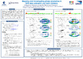
Phase anomalies are generally observed when the satellite orbit crosses regions where ionospheric scintillations occur, which are defined as rapid fluctuations in phase and amplitude of the GNSS signals. The occurrence of scintillations exhibits large day-to-day variations and depends mainly on geomagnetic latitude, season and local time. At low latitudes, maximum occurrence of scintillations is observed 15-20° on either side of the geomagnetic equator. Scintillations also occur at auroral and polar latitudes, where their intensity increases with increasing geomagnetic activity.
This paper aims at detecting, mapping and understanding the phase anomalies experienced by LEO satellites and analyzing their correlation with geomagnetic activity, latitude, season and local time. Several LEO satellites at different altitudes are analyzed (e.g. SWARM, GRACE or JASON), which allows a multi-layer analysis of the underlying ionospheric phenomenon, including scintillation. The latter are generally measured with several indices, like the amplitude index S4 or the phase index SigmaPhi (σφ), which are usually derived from 100Hz measurements performed by dedicated scintillation monitors. In this study, we compute a similar index (called pseudo-σφ) using GPS phase data at 1Hz coming from POD GNSS antenna. A detailed study of the occurrence rate and the severity of pseudo-σφ, together with cycle slips and other spurious phase data, will be performed for different LEO satellites.
Disciplines :
Physical, chemical, mathematical & earth Sciences: Multidisciplinary, general & others
Earth sciences & physical geography
Space science, astronomy & astrophysics