Caours; Eemian; Achaeozoology; Geographic Information System; Eemien; Archéozoologie; Système d'Information Géographique
Abstract :
[en] The Palaeolithic deposit of Caours, located in the Somme, is the only Eemian site in Northern Europe in interglacial context. This site show an incredible conservation of faunal remains spread out over a large area and a recurrence Human occupation. That gave us a large amount of data about this period of Neanderthal history. We now questioning about the choice of this locality and the spatial organisation of Neanderthal. Then, spatial analysis using the Geographic Information System (GIS) appear to being a useful tool to answer it. We show the consequent availability of water, prey and tool raw material. Neanderthalians was opportunistic hunters of cervidae. There has also eat a heavier prey as aurochs and rhino by trapping or scavenging. Then Neanderthal of Caours butchering with tool made in-situ eating the meat and the marrow. [fr] Le gisement paléolithique de Caours, dans la Somme, représente à ce jour un des seuls
sites d’Europe du Nord en contexte interglaciaire – Eémien. Les conditions de conservation des
restes fauniques, la récurrence des occupations et la grande superficie du site ont fourni une
masse considérable de données pour cette période peu connue de l’histoire des
Néandertaliens. Les questions de la fonction du site et de son organisation spatiale se sont très
vite posées. Les analyses spatiales à l’aide des Systèmes d’Information Géographiques (SIG)
sont apparues comme la méthode la plus performante pour répondre à ces questions.
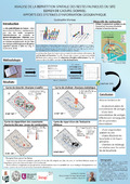
Grace à cette méthode nous avons mis en évidence une organisation spatiale de chaque
niveau d’occupation en plusieurs aires d’activités de boucherie. Pour les deux niveaux
archéologiques présentant des ossements brulés, l’étude de leur répartition a montré
l’existence de foyers primaires en lien étroit avec les zones d’activité de boucherie. En outre,
l’analyse de la répartition spatiale du matériel lithique, a permis de mettre en évidence des
zones de concentration – interprétées comme des ateliers de débitage – associées
spatialement aux aires de boucherie.
Research Center/Unit :
ULg - Université de Liège
Disciplines :
Archaeology
Author, co-author :
Moreau, Gwénaëlle ; Université de Liège - ULiège > Form. doct. hist., hist. art & archéo. (paysage)
Language :
French
Title :
Analyse de la répartition spatiale des restes fauniques du site éémien de Caours. Apport des systèmes d'information géographique.
Alternative titles :
[en] Spatial repartition analysis of faunal remains of the eemian site of Caours. Contribution of Geographic Information Systems.
Publication date :
12 December 2015
Number of pages :
A1
Event name :
Groupe de Contact F.N.R.S. Préhistoire – Malines 2015