
  | Smittarello, D., Grandin, R., Jaspard, M., De Rauw, D., d'Oreye, N., Shreve, T., Debret, M., Theys, N., & Brenot, H. (October 2023). Nyiragongo Crater Collapses Measured by Multi‐Sensor SAR Amplitude Time Series. Journal of Geophysical Research. Solid Earth, 128 (10). doi:10.1029/2023jb026683  Peer Reviewed verified by ORBi Peer Reviewed verified by ORBi |
 | Dille, A., Dewitte, O., Handwerger, A. L., d’Oreye, N., De Rauw, D., Ganza Bamulezi, G., Ilombe Mawe, G., Michellier, C., Moeyersons, J., Monsieurs, E., Mugaruka Bibentyo, T., Samsonov, S., Smets, B., Kervyn, M., & Kervyn, F. (December 2022). Acceleration of a large deep-seated tropical landslide due to urbanization feedbacks. Nature Geoscience, 15 (12), 1048 - 1055. doi:10.1038/s41561-022-01073-3 Peer Reviewed verified by ORBi |
 | Melchor, I., Almendros, J., Hantusch, M., Samsonov, S., De Rauw, D., Martínez, E., & Caselli, A. (December 2022). Long-duration seismicity and their relation to Copahue volcano unrest. Earth, Planets, and Space, 74 (1). doi:10.1186/s40623-021-01561-7 Peer Reviewed verified by ORBi |
 | Smittarello, D., Smets, B., Barrière, J., Michellier, C., Oth, A., Shreve, T., Grandin, R., Theys, N., Brenot, H., Cayol, V., Allard, P., Caudron, C., Chevrel, O., Darchambeau, F., de Buyl, P., Delhaye, L., De Rauw, D., Ganci, G., Geirsson, H., ... Syavulisembo Muhindo, A. (September 2022). Precursor-free eruption triggered by edifice rupture at Nyiragongo volcano. Nature, 609 (7925), 83 - 88. doi:10.1038/s41586-022-05047-8 Peer Reviewed verified by ORBi |
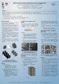
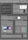 | Glaude, Q., Kirkove, M., De Rauw, D., & Orban, A. (26 May 2022). Plug-In of CSL InSAR Suite (CIS) Functionalities into the SentiNel Application Platform (SNAP) Software [Poster presentation]. 2022 Living Planet Symposium, Bonn, Germany. |
 | Barrière, J., Nicolas, D., Smets, B., Oth, A., Delhaye, L., Subira Muhindo, J., Mashagiro, N., Derauw, D., Smittarello, D., Syavulisembo, A. M., & Kervyn, F. (01 April 2022). Intra-Crater Eruption Dynamics at Nyiragongo (D.R. Congo), 2002–2021. Journal of Geophysical Research. Solid Earth, 127 (4). doi:10.1029/2021JB023858 Peer Reviewed verified by ORBi |
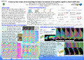
 | Smittarello, D., d’Oreye, N., Jaspard, M., De Rauw, D., & Samsonov, S. (26 February 2022). Pair Selection Optimization for InSAR Time Series Processing. Journal of Geophysical Research. Solid Earth, 127 (3). doi:10.1029/2021jb022825 Peer Reviewed verified by ORBi |
 | Kirkove, M., Glaude, Q., De Rauw, D., Barbier, C., Pattyn, F., & Orban, A. (2021). Sentinel-1 azimuth subbanding for multiple aperture interferometry - Test case over the Roi Baudoin ice shelf, east Antartica. In 2021 IGARSS: IEEE International Geoscience & Remote Sensing Symposium. Proceedings : July 12-16, 2021, Brussels (Belgium). doi:10.1109/IGARSS47720.2021.9553522 Peer reviewed |
  | Glaude, Q., De Rauw, D., Barbier, C., & Pattyn, F. (2021). The Added-Value of TOPSAR Coherence Tracking for Sentinel-1 Interferometry Over Ice Shelves. In EUSAR 2021; 13th European Conference on Synthetic Aperture Radar. Peer reviewed |
 | Glaude, Q., De Rauw, D., Barbier, C., & Pattyn, F. (2021). Fast Azimuthal Displacement Retrieval from TOPSAR Burst Overlapping Interferometry: Application in Dronning Maud Land (Antarctica). In EUSAR 2021; 13th European Conference on Synthetic Aperture Radar. Peer reviewed |
 | Glaude, Q., De Rauw, D., Barbier, C., & Pattyn, F. (01 June 2021). Coherence Tracking and its Adaptation to TOPSAR Acquisition Mode - Study case over Antarctic Ice Shelves [Paper presentation]. FRINGE 2021. |
 | Dille, A., Kervyn, F., Handwerger, A. L., d'Oreye, N., De Rauw, D., Mugaruka Bibentyo, T., Samsonov, S., Malet, J.-P., Kervyn, M., & Dewitte, O. (June 2021). When image correlation is needed: Unravelling the complex dynamics of a slow-moving landslide in the tropics with dense radar and optical time series. Remote Sensing of Environment, 258, 112402. doi:10.1016/j.rse.2021.112402 Peer Reviewed verified by ORBi |
 | d'Oreye, N., De Rauw, D., Samsonov, S., Jaspard, M., & Smittarello, D. (2021). MASTER: A FULL AUTOMATIC MULTI-SATELLITE INSAR MASS PROCESSING TOOL FOR RAPID INCREMENTAL 2D GROUND DEFORMATION TIME SERIES. In IGARSS 2021 - 2021 IEEE International Geoscience and Remote Sensing Symposium, Proceedings. Institute of Electrical and Electronics Engineers Inc. doi:10.1109/IGARSS47720.2021.9553615 Peer reviewed |
 | Barrière, J., d’Oreye, N., Oth, A., Delhaye, L., Subira Muhindo, J., Mashagiro, N., De Rauw, D., Smittarello, D., Muhindo Syavulisembo, A., Kervyn, F., & Smets, B. (2021). On the origins of intracrateral eruption dynamics at Nyiragongo volcano in the period 2002-2021 [Paper presentation]. AGU FALL MEETING 2021, New Orleans, United States - Louisiana. |
 | De Rauw, D., d'Oreye, N., Jaspard, M., Caselli, A., & Samsonov, S. (2020). Ongoing automated ground deformation monitoring of Domuyo - Laguna del Maule area (Argentina) using Sentinel-1 MSBAS time series: Methodology description and first observations for the period 2015–2020. Journal of South American Earth Sciences. doi:10.1016/j.jsames.2020.102850 Peer Reviewed verified by ORBi |
 | Glaude, Q., Amory, C., Berger, S., De Rauw, D., Pattyn, F., Barbier, C., & Orban, A. (10 July 2020). Empirical Removal of Tides and Inverse Barometer Effect on DInSAR From Double DInSAR and a Regional Climate Model. IEEE Journal of Selected Topics in Applied Earth Observations and Remote Sensing, 13, 4085 - 4094. doi:10.1109/JSTARS.2020.3008497 Peer Reviewed verified by ORBi |
 | Defrere, D., Radioti, A., De Rauw, D., Glaude, Q., Libert, L., Orban, A., Barbier, C., Kirkove, M., D'Oreye, N., & Kervyn, F. (28 November 2019). MUZUBI – Advanced phase unwrapping using split-band interferometry [Paper presentation]. BEODay 2019, Belgium. |
 | Defrere, D., Radioti, A., Libert, L., De Rauw, D., Glaude, Q., Kirkove, M., Orban, A., & Barbier, C. (24 October 2019). Fundamental Limit of Absolute Phase Retrieval with Split-Band Interferometry: Application to TerraSAR-X / TanDEM-X and SENTINEL Images [Paper presentation]. Tandem-X science team meeting, Munich, Germany. |
 | Kirkove, M., De Rauw, D., & Orban, A. (15 May 2019). Split-band SAR Interferometry For Vessel Tracking: Application On Sentinel-1 Data [Poster presentation]. ESA Living Planet Symposium 2019, Milan, Italy. |
 | Libert, L., De Rauw, D., d'Oreye, N., Orban, A., & Barbier, C. (2018). On the characterization of frequency-persistent scatterers in Split-Band Interferometry. In IGARSS 2018: 2018 IEEE International Geoscience & Remote Sensing Symposium : proceedings : July 22-27, 2018, Valencia, Spain (pp. 1332-1335). Piscataway, United States - New Jersey: Institute of Electrical and Electronics Engineers. doi:10.1109/IGARSS.2018.8517462 Peer reviewed |
 | De Rauw, D., Kirkove, M., Libert, L., Orban, A., & d'Oreye, N. (19 April 2018). Split-Band SAR and Split Band InSAR principle and applications [Poster presentation]. Luxembourg Earth Observation Day 2018. |
 | Libert, L., De Rauw, D., & Barbier, C. (2017). Optimum split-band parameters for phase offset retrieval. IEEE International Geoscience and Remote Sensing Symposium. doi:10.1109/IGARSS.2017.8126900 Peer reviewed |
Libert, L., De Rauw, D., & d'Oreye, N. (07 November 2017). Development of an Interferometric Mass Processing Chain for Multitemporal Ground Deformation Measurements [Paper presentation]. 99th Journées Luxembourgeoises de la Géodynamique, Luxembourg, Luxembourg. |
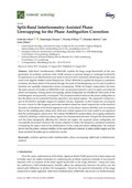 | Libert, L., De Rauw, D., d'Oreye, N., Barbier, C., & Orban, A. (23 August 2017). Split-Band Interferometry-Assisted Phase Unwrapping for the Phase Ambiguities Correction. Remote Sensing, 9 (9). doi:10.3390/rs9090879 Peer Reviewed verified by ORBi |
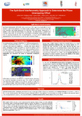 | Libert, L., De Rauw, D., d'Oreye, N., Orban, A., & Barbier, C. (June 2017). The Split-Band Interferometry Approach to Determine the Phase Unwrapping Offset [Poster presentation]. Ludivine Libert, Helsinki, Finland. |
 | Furuya, M., Suzuki, T., & De Rauw, D. (15 December 2016). A step-by-step recipe of band-spli3ng technique for isola8on of ionospheric signal in L-band InSAR data [Poster presentation]. American Geophysical Union (AGU) fall meeting, San Francisco, United States. |
Grodent, C., Guiot, M., Marquet, B., De Rauw, D., Jacobs, J., Samain, V., Flores-Velasco, T., Autenzio, P., & preumont, P. (November 2016). Development of a closed loop turn-key high performance Thermal Conditioning Unit for Space applications [Paper presentation]. 29th Space Simulation conference, Annapolis, Maryland, USA, Annapolis, United States. |
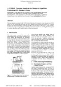 | Kirkove, M., Orban, A., De Rauw, D., & Barbier, C. (2016). A TOPSAR Processor based on the Omega-K Algorithm: Evaluation with Sentinel-1 Data. In A TOPSAR Processor based on the Omega-K Algorithm: Evaluation with Sentinel-1 Data. Peer reviewed |
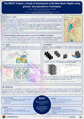 | Libert, L., d'Oreye, N., Kervyn, F., De Rauw, D., & Barbier, C. (September 2015). The RESIST Project: a Study of Geohazards in the Kivu Basin Region using ground- and space borne Techniques [Poster presentation]. 6th Advance Training Course on Land Remote Sensing, Bucarest, Romania. |
 | De Rauw, D., Kervyn, F., d'Oreye, N., Smets, B., Albino, F., & Barbier, C. (2015). Split-Band Interferometric SAR Processing Using TanDEM-X Data. In ESA SP-731. |
 | De Rauw, D., & Barbier, C. (2014). Spectral coherence applied to vessel tracking. Radar, IEEE International Conference. doi:10.1109/RADAR.2014.7060291 |
 | Bovenga, F., Barbier, C., De Rauw, D., Rana, F. M., Refice, A., Veneziani, N., & Vitulli, R. (19 September 2014). Multi-Chromatic Analysis of SAR Images for Coherent Target Detection. Remote Sensing, 6, 8822-8843. doi:10.3390/rs6098822 Peer Reviewed verified by ORBi |
 | Barbier, C., De Rauw, D., Orban, A., & Davidson, M. (2014). Study of a Passive Companion Micro-Satellite to the SAOCOM-1B Satellite of Argentina, for Bistatic and Interferometric SAR Applications. In Spie, Proceedings SPIE Remote Sensing Conference 9241 Sensors, Systems, and Next-Generation Satellites. Peer reviewed |
 | Orban, A., Barbier, C., & De Rauw, D. (September 2012). Determining Tree Height by Polarimetric SAR Interferometry: Methodology [Poster presentation]. Argentinian Congress of Earth Observation, Cordoba, Argentina. |
 | De Rauw, D., Orban, A., & Barbier, C. (September 2010). Wide band SAR sub-band splitting and inter-band coherence measurements. Remote Sensing Letters, 1 (3), 133-140. doi:10.1080/01431160903329356 Peer Reviewed verified by ORBi |
 | Bodart, C., Ozer, A., & De Rauw, D. (2010). Suivi de l’activité des dunes au Niger au moyen de la cohérence interférométrique ERS ½. Bulletin de la Société Géographique de Liège, 54 (1), 123-136. Peer Reviewed verified by ORBi |
 | De Rauw, D., Mazy, E., Stockman, Y., & Popovich, A. (18 November 2009). Alignement et optimisation d'un simulateur solaire d'une configuration de 1SC à une configuration à 10SC [Paper presentation]. Dixième colloque international francophone : Méthodes et Techniques Optiques pour l'Industrie, Reims, France. |
 | De Rauw, D. (September 2009). A proof of concept of Iterative DSM improvement through SAR scene simulation. ISPRS Journal of Photogrammetry and Remote Sensing, XXXVIII (3/W4), 121-126. Peer Reviewed verified by ORBi |
 | Groves, R., De Rauw, D., Thizy, C., Alexeenko, I., Osten, W., Georges, M., & Tornari, V. (2009). Automated Phase Map Referencing Against Historic Map Data. In W. Osten & M. Kujawinska (Eds.), Fringe 2009 (pp. 193-196). Berlin, Germany: Springer. doi:10.1007/978-3-642-03051-2_31 |
 | De Rauw, D., Orban, A., & Barbier, C. (September 2009). Inter-band Coherence of Split Wide Band SAR Images; A Potentially New Information Channel. EARSel Newsletter, 79, 22-27. Peer reviewed |
 | Thizy, C., De Rauw, D., Georges, M., Kouloumpi, E., & Hackney, S. (2008). Role of photorefractive holographic interferometry in Impact Assessment Procedure applied to movable cultural heritage. In Proceedings of the International Symposium to Commemorate the 60th Anniversary of the Invention of Holography (pp. 164-169). Bethel, CT, United States: Society for Experimental Mechanics. |
 | De Rauw, D., & Barbier, C. (2008). Chirp-Z Transformed Based Interpolator Adaptation for Range Migration Correction. In Proc. EUSAR'08 Conference. Peer reviewed |
 | De Rauw, D., & Belmonte, A. (November 2007). Numerical error analysis of CSL georeferencing process implementation [Poster presentation]. De Rauw, Frascati, Italy. |
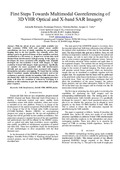 | Belmonte, A., De Rauw, D., Barbier, C., & Verly, J. (2007). First Steps Towards Georeferencing of 3D VHR Optical and X-Band SAR Imagery. In Proc. IGARSS'07 Symposium. Peer reviewed |
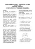
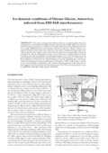 | Pattyn, F., & De Rauw, D. (2002). Ice-dynamic conditions of Shirase Glacier, Antarctica, inferred from ERS SAR interferometry. Journal of Glaciology, 48 (163), 559-565. doi:10.3189/172756502781831115 Peer Reviewed verified by ORBi |
Closson, D., Cornet, Y., Ozer, A., Hansen, H., De Rauw, D., & Barbier, C. (1999). Cartography of Microclimatic Zones Using InSAR DTM. In ESA (Ed.), Proc. FRINGE'99 Symposium. Peer reviewed |
Blaes, X., Defourny, P., De Rauw, D., & Barbier, C. (1999). InSAR Coherence for Crop Parameter Monitoring. In ESA (Ed.), Proc. FRINGE'99 Symposium. Peer reviewed |
De Rauw, D., & Barbier, C. (1998). Quality Assessment of InSAR Topographic Mapping : The Example of Belgium. In SPIE (Ed.), Proc. SPIE (pp. 175-185). Peer reviewed |
Cornet, Y., De Rauw, D., Ozer, A., Moxhet, J., Closson, D., Doulliez, J.-Y., Ozer, P., & Kourgli, A. (1998). Interférométrie RSO et analyses géomorphométriques à caractère tectonique en Jordanie. In J. M. Dubois, M. Bernier, J. P. Fortin, ... F. Boivin (Eds.), Série Actualité scientifique - La réalité de terrain en télédétection: pratiques et méthodes. Canada: Presses de l'Université du Québec. Peer reviewed |
Cornet, Y., Doulliez, J.-Y., Moxhet, J., Closson, D., Kourgli, A., Ozer, A., Ozer, P., & De Rauw, D. (1997). Use of ERS tandem data to produce digital elevation models by interferometry and study land movements by differential interferometry in Calabria and Jordan [Paper presentation]. Third ERS Symposium "Space at the service of our environment", Florence, Italy. Peer reviewed |
Troch, P. A., De Troch, F. P., Grayson, R., Western, A., De Rauw, D., & Barbier, C. (1997). Spatial Organization of Hydrological Processes in Small Catchments Derived from Advanced SAR Image Processing : Field Work and Preliminary Results. In ESA (Ed.), ESA Special Publication (pp. 93-97). Peer reviewed |
 | De Rauw, D., & Roose, S. (1995). Co-registration and complex interpolation. In G. Franceschetti, C. Oliver, J. Shiue, ... S. Tajbakhsh (Eds.), Synthetic Aperture Radar and Passive Microwave Sensing. Bellingham, United States: SPIE. doi:10.1117/12.227142 |
Barbier, C., Renson, L., De Rauw, D., Mertens, O., Cantraine, Dendal, D., Destiné, J., Pannaije, A., & Marchand, J.-L. (1993). Study and Development of a SAR Azimuth Compression - Autofocusing Processor Based on the w-k Seismic Migration Technique. ESA Journal, 17, 357-371. Peer reviewed |