
  | Carré, C., & Hamdani, Y. (22 March 2021). Pyramidal Framework: Guidance for the Next Generation of GIS Spatial-Temporal Models. ISPRS International Journal of Geo-Information, 10. doi:10.3390/ijgi10030188  Peer Reviewed verified by ORBi Peer Reviewed verified by ORBi |
 | Pfeiffer, M., Eller, D., & Carré, C. (June 2020). Toward a virtual research environment for the spatial humanities: heiMAP. Digital Scholarship in the Humanities, 35 (2). doi:10.1093/llc/fqz032 Peer Reviewed verified by ORBi |
 | Carré, C. (2020). Conception d'une ontologie spatio-temporelle dédiée au suivi de l'évolution des objets géographiques [Doctoral thesis, ULiège - Université de Liège]. ORBi-University of Liège. https://orbi.uliege.be/handle/2268/245248 |
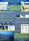 | Sirjacobs, D., Le Carrer, J., Katz, L., Agüera, A., Donnay, A., Carré, C., Leduc, M., Danis, B., Gobert, S., & Lejeune, P. (26 August 2019). Completing forty years of investigation on macroalgal distributions in Calvi Bay (Corsica, France) [Poster presentation]. 7th European Phycology Congress - EPC7, Zagreb, Croatia. |
  | Agnello, A., Carré, C., Billen, R., Leyh, B., De Pauw, E., & Damblon, C. (2018). ULg Spectra: An Interactive Software Tool To Improve Undergraduate Students’ Structural Analysis Skills. Journal of Chemical Education, 95, 276-280. doi:10.1021/acs.jchemed.7b00712 Peer Reviewed verified by ORBi |
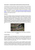
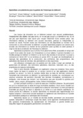
 | Billen, R., Van Ruymbeke, M., Pfeiffer, M., Carré, C., Jonlet, B., Poux, F., Luczfalvy Jancsó, A., Neuville, R., & Hallot, P. (20 April 2016). Vers des systèmes d’information archéologique : maquette virtuelle et nuages de points intelligents [Paper presentation]. Maquettes et restitutions, Lille, France. |
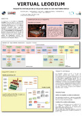
Carré, C. (2016). Virtual Leodium - Modélisation 3D de la ville de Liège - Etat d’avancement mars 2016. |
 | Billen, R., Van Ruymbeke, M., & Carré, C. (27 November 2015). Virtual Leodium: un exemple de gestion spatio-temporelle de données patrimoniales [Paper presentation]. "Des levés, pourquoi ?" Levés et représentations du patrimoine, le visible et l'invisible, Namur, Belgium. |
Carré, C. (2015). Virtual Leodium - Modélisation 3D de la Cathédrale Saint-Lambert de Liège. |
Carré, C. (2015). Virtual Leodium - Modélisation 3D de la ville de Liège. |
 | Van Ruymbeke, M., Carré, C., Delfosse, V., Pfeiffer, M., & Billen, R. (2015). Towards an Archaeological Information System: Improving the Core Data Model. In F. Giligny, F. Djindjian, L. Costa, P. Moscati, ... S. Robert (Eds.), CAA 2014 21st century Archaeology : Concepts methods and tools : Proceedings of the 42nd Annual Conference on Computer Applications and Quantitative Methods in Archaeology (pp. 245-253). Oxford, United Kingdom: Archaeopress. Peer reviewed |
 | Carré, C. (04 December 2014). Liege - Nantes: historical scale models acquisition and data modeling [Paper presentation]. VISIONAIR General Assembly 4, Rennes, France. |
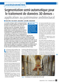 | Poux, F., Hallot, P., Jonlet, B., Carré, C., & Billen, R. (December 2014). Segmentation semi-automatique pour le traitement de données 3D denses : application au patrimoine architectural. XYZ: la Revue de l'Association Française de Topographie, 141 (36), 69-75. Peer reviewed |
 | Delfosse, V., Boulanger, C., Jeunejean, A., Carré, C., Billen, R., & Leclercq, P. (2014). SPATIODATA, un modèle de bâtiment non-constructif, collaboratif et multi-usage. In Actes du 6ème Séminaire de Conception Architecturale Numérique. Peer reviewed |
 | Ben Rajeb, S., Delfosse, V., Boulanger, C., Jeunejean, A., Carré, C., Billen, R., & Leclercq, P. (2014). Projet de recherche appliquée SpatioData : Spécification d’un système participatif pour la réutilisation de données sporadiques sur le bâtiment. In Proceedings du colloque 01'Design 9. Peer reviewed |
 | Van Ruymbeke, M., Carré, C., Delfosse, V., Hallot, P., Pfeiffer, M., & Billen, R. (25 April 2014). Towards an Archaeological Information System: improving the core data model [Paper presentation]. Computer Applications and Quantitative Methods in Archaeology. CAA 2014, Paris, France. |
 | Carré, C., Delfosse, V., Billen, R., Jeunejean, A., Boulanger, C., Vandervreken, A., Lefèbvre, P.-H., Michel, B., & Leclercq, P. (2013). SPATIODATA, une approche alternative pour la gestion des données spatialisées relatives aux bâtiments. In Thibaud (Ed.), Gourmelon (Ed.), J. Gensel (Ed.), T. Joliveau (Ed.), C. Claramunt (Ed.), ... A. Ruas (Other coll.), SAGEO 2013 - Conférence internationale de Géomatique et d'analyse spatiale - ACTES de la Conférence. Peer reviewed |
 | Pfeiffer, M., Carré, C., Delfosse, V., Hallot, P., & Billen, R. (2013). Virtual Leodium: From an historical 3D city scale model to an archaeological information system. In Grussenmeyer (Ed.), ISPRS Annals – Volume II-5/W1, 2013. Strasbourg, France: Copernicus Publications. Peer reviewed |
 | Carré, C., Delfosse, V., Jeunejean, A., Vandervreken, A., Boulanger, C., Lefebvre, P.-H., Michel, B., Billen, R., & Leclercq, P. (24 May 2013). SpatioData: a platform for building information management [Paper presentation]. 5th Belgian Geographical Days, Louvain-la-Neuve, Belgium. |
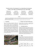 | Pfeiffer, M., Carré, C., Delfosse, V., & Billen, R. (14 May 2013). Virtual Leodium: Development of an archaeological information system, a case study on an historical 3D city scale model [Paper presentation]. AGILE 2013 - Workshop on INTEGRATING 4D, GIS AND CULTURAL HERITAGE, Leuven, Belgium. |
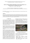
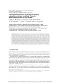 | Hervy, Billen, R., Laroche, F., Carré, C., Servières, M., Van Ruymbeke, M., & Tourre, V. (2012). A generalized approach for historical mock-up acquisition and data modelling: towards historically enriched 3D city models. In T. Leduc, G. Moreau, ... R. Billen (Eds.), Usage, Usability, and Utility of 3D City models. Les Ulis, France: edp Sciences. doi:10.1051/3u3d/201202009 Peer reviewed |
 | Billen, R., Carré, C., Delfosse, V., Hervy, B., Laroche, F., Lefevre, D., Servières, M., & Van Ruymbeke, M. (2012). 3D historical models: the case studies of Liege and Nantes. In R. Billen, M. Caglioni, O. Marina, G. Rabino, ... R. San José (Eds.), 3D issues in urban and environmental systems. Bologna, Italy: Società Editrice Esculapio Srl. Peer reviewed |
 | Van Ruymbeke, M., Carré, C., & Billen, R. (2012). L'existant et l'ayant existé. Documenter le patrimoine dans la diachronie. Thema & Collecta, (2), 43 - 51. Peer reviewed |
Billen, R., Carré, C., Van Ruymbeke, M., Schenke, C., Habraken, S., Laven, N., Thirion, P., Martin, G., & Blain, P. (2011). Virtual Leodium - vidéo de présentation. |
 | Guillaumont, B., Carré, C., van den Beld, I., & Davies, J. (June 2011). Analysing videos and still images of vulnerable marine ecosystems in the deep-sea: a practical application using COVER [Paper presentation]. MESH Atlantic Workshop, Faro, Portugal. |
 | Guillaumont, B., Carré, C., van den Beld, I., Beuck, L., & Davies, J. (June 2011). Methodology of annotating videos and still images and development of the software COVER [Paper presentation]. MESH Atlantic Workshop, Faro, Portugal. |
 | Guillaumont, B., Carré, C., Van Den Beld, Beuck, L., & Davies, J. (May 2011). Annotating optical images from ROVs or towed cameras in Vulnerable Marine Ecosystems studies [Poster presentation]. GeoHab 2011, Helsinki, Finland. |
 | Billen, R., Blain, P., Carré, C., Habraken, S., Renotte, Y., Silva, V., & Van Ruymbeke, M. (13 April 2011). Virtual Leodium: Maquette virtuelle de la ville de Liège au dix-huitième siècle [Poster presentation]. Archéométrie 2011. Colloque du GMPCA, Liège, Belgium. |
 | Carré, C. (December 2010). COVER software for video annotation [Paper presentation]. CoralFISH 2nd Science Meeting, Milan, Italy. |
 | Carré, C. (May 2010). Identification of Deep sea Flora on Video Imagery [Paper presentation]. ICES WGMHM 2010 Meeeting, Calvi, France. |
Carré, C. (2009). Implémentation de modules d'interrogation et de visualisation de données 3D dans le cadre du développement d'un système intégré de l'information 3D urbaine [Master’s dissertation, Ecole Supérieure des Géomètres et Topographes]. ORBi-University of Liège. https://orbi.uliege.be/handle/2268/257499 |