[en] In the context of the climate and biodiversity crisis facing our planet, tropical forests playing
a key role in global carbon flux and containing over half of Earth’s species are important to preserve.
They are today threatened by deforestation but also by forest degradation, which is more difficult to
study. Here, we performed a systematic review of studies on moist tropical forest degradation using
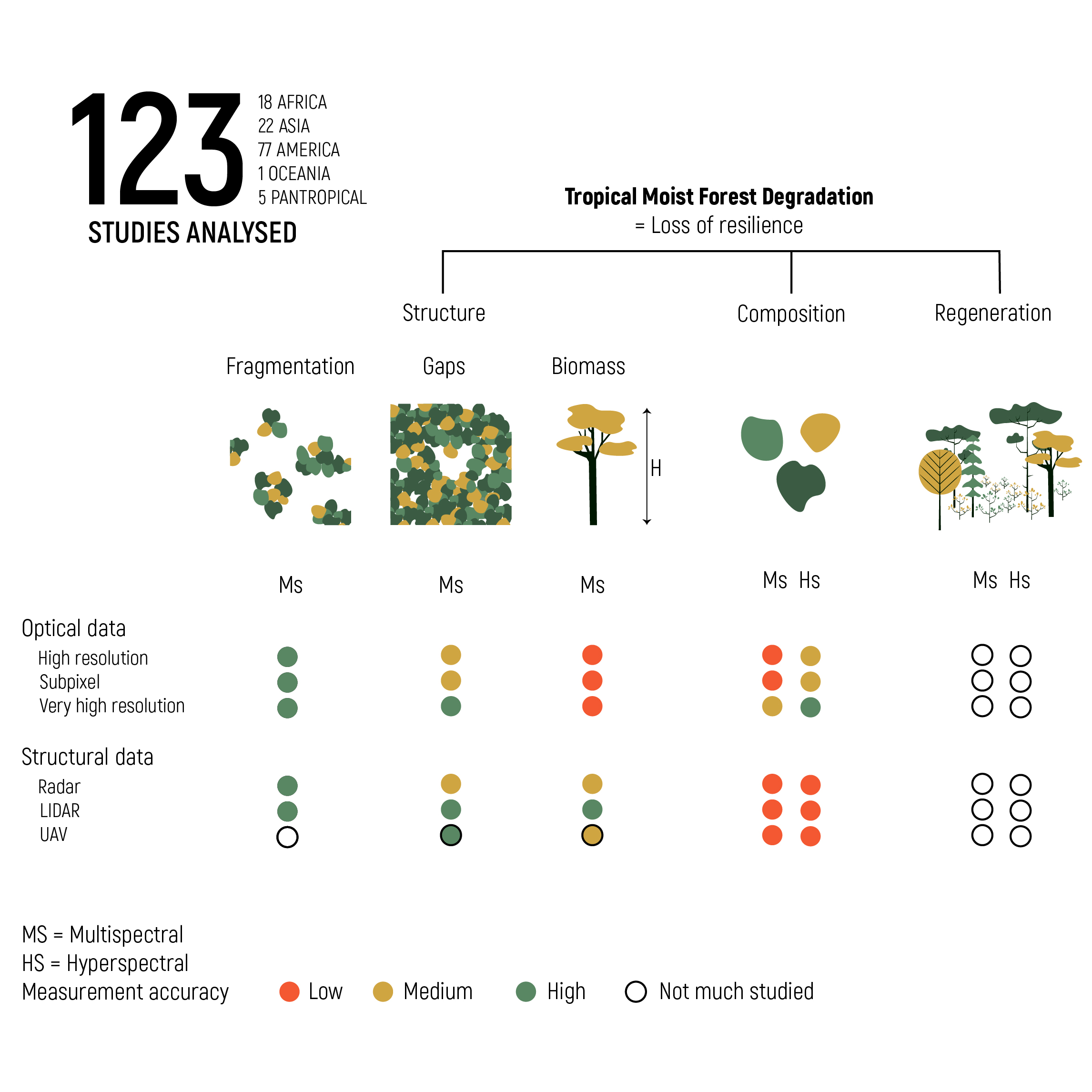
remote sensing and fitting indicators of forest resilience to perturbations. Geographical repartition,
spatial extent and temporal evolution were analyzed. Indicators of compositional, structural and
regeneration criteria were noted as well as remote sensing indices and metrics used. Tropical moist
forest degradation is not extensively studied especially in the Congo basin and in southeast Asia.
Forest structure (i.e., canopy gaps, fragmentation and biomass) is the most widely and easily measured
criteria with remote sensing, while composition and regeneration are more difficult to characterize.
Mixing LiDAR/Radar and optical data shows good potential as well as very high-resolution satellite
data. The awaited GEDI and BIOMASS satellites data will fill the actual gap to a large extent and
provide accurate structural information. LiDAR and unmanned aerial vehicles (UAVs) form a good
bridge between field and satellite data. While the performance of the LiDAR is no longer to be
demonstrated, particular attention should be brought to the UAV that shows great potential and
could be more easily used by local communities and stakeholders.
Centre de recherche :
TERRA Research Centre - TERRA
Disciplines :
Sciences de l’environnement & écologie Ingénierie, informatique & technologie: Multidisciplinaire, généralités & autres
Auteur, co-auteur :
Dupuis, Chloé ; Université de Liège - ULiège > Département GxABT > Gestion des ressources forestières et des milieux naturels
Lejeune, Philippe ; Université de Liège - ULiège > Département GxABT > Gestion des ressources forestières et des milieux naturels
Michez, Adrien ; Université de Liège - ULiège > Département GxABT > Gestion des ressources forestières et des milieux naturels
Fayolle, Adeline ; Université de Liège - ULiège > Département GxABT > Gestion des ressources forestières et des milieux naturels
Langue du document :
Anglais
Titre :
How Can Remote Sensing Help Monitor Tropical Moist Forest Degradation?—A Systematic Review
Date de publication/diffusion :
28 mars 2020
Titre du périodique :
Remote Sensing
eISSN :
2072-4292
Maison d'édition :
Multidisciplinary Digital Publishing Institute (MDPI), Basel, Suisse
IPCC. Global Warming of 1.5 C-An IPCC Special Report on the Impacts of Global Warming of 1.5 ffiC above Pre-Industrial Levels and Related Global Greenhouse Gas Emission Pathways, in the Context of Strengthening the Global Response to the Threat of Climate Chang; IPCC: Incheon, Korea, 2018.
IPBES. Report of the Plenary of the Intergovernmental Science-Policy Platform on Biodiversity and Ecosystem Services on the Work of Its Seventh Session; IPBES: Paris, France, 2019.
Ceballos, G.; Ehrlich, P.R.; Dirzo, R. Biological Annihilation via the Ongoing Sixth Mass Extinction Signaled by Vertebrate Population Losses and Declines. PNAS 2017, 114, 6089-6096.
Lewis, S.L.; Edwards, D.P.; Galbraith, D. Increasing Human Dominance of Tropical Forests. Science 2015, 349, 827-832.
Costanza, R.; D'Arge, R.; de Groot, R.; Farber, S.; Grasso, M.; Hannon, B.; Limburg, K.; Naeem, S.; O'Neill, R.V.; Paruelo, J.; et al. The Value of theWorld's Ecosystem Services and Natural Capital. Nature 1997, 387, 253-260.
FAO. Assessing Forest Degradation-Towards the Development of Globally Applicable Guidlines; FAO: Rome, Italy, 2011.
Pan, Y.; Birdsey, R.; Fang, J.; Houghton, R.; Kauppi, P.E.; Kurz, W.A.; Phillips, O.L.; Shvidenko, A.; Lewis, S.L.; Canadell, J.G.; et al. A Large and Persistent Carbon Sink in theWorld's Forests. Science 2011, 333, 988-994.
Mitchard, E.T.A. The Tropical Forest Carbon Cycle and Climate Change. Nature 2018, 559, 527-534.
Pearson, T.R.H.; Brown, S.; Murray, L.; Sidman, G. Greenhouse Gas Emissions from Tropical Forest Degradation: An Underestimated Source. Carbon Balance Manag. 2017, 12, 1-11.
Abernethy, K.; Maisels, F.; White, L.J.T. Environmental Issues in Central Africa. Annu. Rev. Environ. Resour. 2016, 41, 1-33.
Achard, F.; Beuchle, R.; Mayaux, P.; Stibig, H.J.; Bodart, C.; Brink, A.; Carboni, S.; Desclée, B.; Donnay, F.; Eva, H.D.; et al. Determination of Tropical Deforestation Rates and Related Carbon Losses from 1990 to 2010. Glob. Chang. Biol. 2014, 20, 2540-2554.
Tyukavina, A.; Baccini, A.; Hansen, M.C.; Potapov, P.V.; Stehman, S.V.; Houghton, R.A.; Krylov, A.M.; Turubanova, S.; Goetz, S.J. Aboveground Carbon Loss in Natural and Managed Tropical Forests from 2000 to 2012. Environ. Res. Lett. 2015, 10.
Keenan, R.J.; Reams, G.A.; Achard, F.; de Freitas, J.V.; Grainger, A.; Lindquist, E. Dynamics of Global Forest Area: Results from the FAO Global Forest Resources Assessment 2015. For. Ecol. Manag. 2015, 352, 9-20.
Song, X.; Hansen, M.C.; Stephen, V.; Peter, V.; Tyukavina, A.; Vermote, E.F.; Townshend, J.R. Global Land Change from 1982 to 2016. Nature 2018, 560, 639-643.
Morales-Hidalgo, D.; Oswalt, S.N.; Somanathan, E. Status and Trends in Global Primary Forest, Protected Areas, and Areas Designated for Conservation of Biodiversity from the Global Forest Resources Assessment 2015. For. Ecol. Manag. 2015, 352, 68-77.
Potapov, P.; Hansen, M.C.; Laestadius, L.; Turubanova, S.; Yaroshenko, A.; Thies, C.; Smith, W.; Zhuravleva, I.; Komarova, A.; Minnemeyer, S.; et al. The Last Frontiers of Wilderness: Tracking Loss of Intact Forest Landscapes from 2000 to 2013. Sci. Adv. 2017, 3, 1-14.
FAO. The State of Forests in the Amazon Basin, Congo Basin and Southeast Asia; FAO: Brazzaville, Republic of Congo, 2011.
Tapia-Armijos, M.F.; Homeier, J.; Espinosa, C.I.; Leuschner, C.; De La Cruz, M. Deforestation and Forest Fragmentation in South Ecuador since the 1970s-Losing a Hotspot of Biodiversity. PLoS ONE 2015, 10, 1-18.
Barlow, J.; Lennox, G.D.; Ferreira, J.; Berenguer, E.; Lees, A.C.; Nally, R.M.; Thomson, J.R.; Ferraz, S.F.D.B.; Louzada, J.; Oliveira, V.H.F.; et al. Anthropogenic Disturbance in Tropical Forests Can Double Biodiversity Loss from Deforestation. Nature 2016, 535, 144-147.
Karamage, F.; Shao, H.; Chen, X.; Ndayisaba, F.; Nahayo, L.; Kayiranga, A.; Omifolaji, J.K.; Liu, T.; Zhang, C. Deforestation Effects on Soil Erosion in the Lake Kivu Basin, D.R. Congo-Rwanda. Forests 2016, 7, 281.
Celentano, D.; Rousseau, G.X.; Engel, V.L.; Zelarayán, M.; Oliveira, E.C.; Araujo, A.C.M.; de Moura, E.G. Degradation of Riparian Forest Affects Soil Properties and Ecosystem Services Provision in Eastern Amazon of Brazil. L. Degrad. Dev. 2016, 28, 482-493.
Priess, J.A.; Mimler, M.; Klein, A.-M.; Schwarze, S.; Tscharntke, T.; Steffan-Dewenter, I. Linking Deforestation Scenarios to Pollination Services and Economic Returns in Coffee Agroforestery Systems. Ecol. Appl. 2007, 17, 407-417.
Ehara, M.; Hyakumura, K.; Nomura, H.; Matsuura, T.; Sokh, H.; Leng, C. Identifying Characteristics of Households Affected by Deforestation in Their Fuelwood and Non-Timber Forest Product Collections: Case Study in Kampong Thom Province, Cambodia. Land Use Policy 2016, 52, 92-102.
Burkett-Cadena, N.D.; Vittor, A.Y. Deforestation and Vector-Borne Disease: Forest Conversion Favors Important Mosquito Vectors of Human Pathogens. Basic Appl. Ecol. 2018, 26, 101-110.
Van derWerf, G.R.; Morton, D.C.; DeFries, R.S.; Olivier, J.G.J.; Kasibhatla, P.S.; Jackson, R.B.; Collatz, G.J.; Randerson, J.T. CO2 Emissions from Forest Loss. Nat. Geosci. 2009, 2, 737-738.
Tyukavina, A.; Hansen, M.C.; Potapov, P.; Parker, D.; Okpa, C.; Stehman, S.V.; Kommareddy, I.; Turubanova, S. Congo Basin Forest Loss Dominated by Increasing Smallholder Clearing. Sci. Adv. 2018, 4, 1-12.
Kissinger, G.; Herold, M.; De Sy, V. Drivers of Deforestation and Forest Degradation: A Synthesis Report for REDD+ Policymakers; The Government of the UK and Norway: Vancouver, Canada, 2012.
The UnitedNations. Sustainable Development Goals. Available online: https://www.un.org/sustainabledevelopment/ (accessed on 30 January 2020).
FAO; UNDP; UNEP. UN-REDD Programme Strategic Framework 2016-2020 (UNREDD/PB14/2015/III/3); UN-REDD Programme fourteenth policy boardmeeting; Washington, DC, USA, 2015; Available online: https://www.google.com.hk/url?sa=t&rct=j&q=&esrc=s&source=web&cd=1&ved=2ahUKEwi7zviqp7zoAhUNUd4KHe1fCTkQFjAAegQIAhAB& url=http%3A%2F%2Fwww.redd-monitor.org%2Fwp-content%2Fuploads%2F2016%2F11%2FUNREDD_PB14_2015_ Strategic-Framework-2016-20-7May2015-130662-1.pdf&usg=AOvVaw01YNiuUx0MuY4OH1UYDtqB (accessed on 12 January 2020).
Ochieng, R.M.; Visseren-Hamakers, I.J.; Arts, B.; Brockhaus, M.; Herold, M. Institutional Effectiveness of REDD+MRV: Countries Progress in Implementing Technical Guidelines and Good Governance Requirements. Environ. Sci. Policy 2016, 61, 42-52.
Simula, M. Vers Une Définition de La Dégradation Des Forêts: Analyse Comparative Des Définitions Existantes; FAO: Rome, Italy, 2009.
Arana Pardo, J.I.; Birdsey, R.; Boehm, M.; Daka, J.; Kobayashi, S.; Lund, H.G.; Michalak, R.; Takahashi, M. IPCC Report on Definitions and Methodological Options to Inventory Emissions from Direct Human-Induced Degradation of Forests and Devegetation of Other Vegetation Types; Institute for Global Environmental Strategies: Hayama, Kanagawa, Japan, 2003; ISBN 4-88788-004-9.
FAO. Global Forest Resources Assessment 2020: Terms and Definition; FAO: Rome, Italy, 2018.
ITTO. ITTO Guidelines for the Restoration, Management and Rehabilitation of Degraded and Secondary Tropical Forests; ITTO Policy Development Series No 13; ITTO: Yokohama, Kanagawa, Japan, 2002.
Vásquez-Grandón, A.; Donoso, P.J.; Gerding, V. Forest Degradation: When Is a Forest Degraded? Forests 2018, 9, 726.
Ghazoul, J.; Chazdon, R. Degradation and Recovery in Changing Forest Landscapes: AMultiscale Conceptual Framework. Annu. Rev. Environ. Resour. 2017, 42, 161-188.
Gourlet-Fleury, S.; Mortier, F.; Fayolle, A.; Baya, F.; Ouédraogo, D.; Bénédet, F.; Picard, N. Tropical Forest Recovery from Logging: A 24 Year Silvicultural Experiment from Central Africa. Philos. Trans. R. Soc. B 2013, 368, 1-10.
Doucet, J.; Daïnou, K.; Ligot, G.; Ouédraogo, D.; Bourland, N.; Ward, S.E.; Tekam, P.; Lagoute, P.; Fayolle, A.; Bourland, N.; et al. Enrichment of Central African Logged Forests with High-Value Tree Species: Testing a New Approach to Regenerating Degraded Forests. Int. J. Biodivers. Sci. Ecosyst. Serv. Manag. 2016, 12, 83-95.
Thompson, I.D.; Guariguata, M.R.; Okabe, K.; Bahamondez, C.; Nasi, R.; Heymell, V.; Sabogal, C. An Operational Framework for Defining and Monitoring Forest Degradation. Ecol. Soc. 2013, 18.
Standish, R.J.; Hobbs, R.J.; Mayfield, M.M.; Bestelmeyer, B.T.; Suding, K.N.; Battaglia, L.L.; Eviner, V.; Hawkes, C.V.; Temperton, V.M.; Cramer, V.A.; et al. Resilience in Ecology: Abstraction, Distraction, or Where the Action Is? Biol. Conserv. 2014, 177, 43-51.
IPCC. 2019 Refinement To the 2006 IPCC Guidelines for National Greenhouse Gas Inventories; IPCC: Geneva, Switzerland, 2019.
GOFC-GOLD. A Sourcebook of Methods and Procedures for Monitoring and Reporting Anthropogenic Greenhouse Gas Emissions and Removals Associated with Deforestation, Gains and Losses of Carbon Stocks in Forests Remaining Forests, and Forestation; GOFC-GOLD Land Cover Project Office: Wageningen, The Netherlands, 2016.
GFOI. Integration of Remote-Sensing and Ground-Based Observations for Estimation of Emissions and Removals of Greenhouse Gases in Forests: Methods and Guidance from the Global Forest Observations Initiative, 2nd ed.; GFOI: Rome, Italy, 2016.
Sanchez-Azofeifa, A.; Antonio Guzmán, J.; Campos, C.A.; Castro, S.; Garcia-Millan, V.; Nightingale, J.; Rankine, C. Twenty-First Century Remote Sensing Technologies Are Revolutionizing the Study of Tropical Forests. Biotropica 2017, 49, 604-619.
Finer, M.; Novoa, S.; Weisse, J.; Petersen, R.; Souto, T.; Stearns, F.; Martinez, R.G. Combating Deforestation: From Satellite to Intervention. Science 2018, 360, 1303-1305.
Mitchell, A.L.; Rosenqvist, A.; Mora, B. Current Remote SensingApproaches to Monitoring Forest Degradation in Support of Countries Measurement, Reporting and Verification (MRV) Systems for REDD+. Carbon Balance Manag. 2017, 12.
Joseph, S.; Murthy, M.S.R.; Thomas, A.P. The Progress on Remote Sensing Technology in Identifying Tropical Forest Degradation: A Synthesis of the Present Knowledge and Future Perspectives. Environ. Earth Sci. 2011, 64, 731-741.
Fry, B.P. Community Forest Monitoring in REDD +: The 'M' in MRV? Environ. Sci. Policy 2011, 14, 181-187.
Paneque-gálvez, J.; Mccall, M.K.; Napoletano, B.M.; Wich, S.A.; Koh, L.P. Small Drones for Community-Based Forest Monitoring: An Assessment of Their Feasibility and Potential in Tropical Areas. Forests 2014, 5, 1481-1507.
de Carvalho, A.L.; D'Oliveria, M.V.N.; Putz, F.E.; de Oliveira, L.C. Natural Regeneration of Trees in Selectively Logged Forest in Western Amazonia. For. Ecol. Manag. 2017, 392, 36-44.
Sufo Kankeu, R.; Sonwa, D.J.; Eba'a Atyi, R.; Moankang Nkal, N.M. Quantifying Post Logging Biomass Loss Using Satellite Images and Ground Measurements in Southeast Cameroon. J. For. Res. 2016, 27, 1415-1426.
Shimabukuro, Y.E.; Beuchle, R.; Grecchi, R.C. Assessment of Forest Degradation in Brazilian Amazon Due to Selective Logging and Fires Using Time Series of Fraction Images Derived from Landsat ETM + Images. Remote Sens. Lett. 2014, 5, 773-782.
Brinck, K.; Fischer, R.; Lehmann, S.; De Paula, M.D.; Putz, S.; Sexton, J.O.; Song, D.; Huth, A. High Resolution Analysis of Tropical Forest Fragmentation and Its Impact on the Global Carbon Cycle. Nat. Commun. 2017, 8.
Taubert, F.; Fischer, R.; Groeneveld, J.; Lehmann, S.; Müller, M.S.; Rödig, E.; Wiegand, T.; Huth, A. Global Patterns of Tropical Forest Fragmentation. Nature 2018, 554, 519-522.
Wade, T.G.; Riitters, K.H.; Wickham, J.D.; Jones, K.B. Distribution and Causes of Global Forest Fragmentation. Conserv. Ecol. 2003, 7, 1-5. Available online: http://www.consecol.org/vol7/iss2/art7/ (accessed on 5 January 2020).
Baccini, A.; Walker, W.; Carvalho, L.; Farina, M.; Houghton, R.A. Tropical Forests Are a Net Carbon Source Based on Aboveground Measurements of Gain and Loss. Science 2017, 358, 230-234.
Rodig, E.; Cuntz, M.; Heinke, J.; Rammig, A.; Huth, A. Spatial Heterogeneity of Biomass and Forest Structure of the Amazon Rain Forest: Linking Remote Sensing, Forest Modelling and Field Inventory. Glob. Ecol. Biogeogr. 2017, 26, 1292-1302.
Dong, J.; Xiao, X.; Sheldon, S.; Biradar, C.; Zhang, G.; Duong, N.D.; Hazarika, M.; Wikantika, K.; Takeuhci, W.; Moore, B. A 50-m Forest Cover Map in Southeast Asia from ALOS/PALSAR and Its Application on Forest Fragmentation Assessment. PLoS ONE 2014, 9.
Lucas, R.M.; Honzák, M.; Curran, P.J.; Foody, G.M.; Nguele, D.T. Characterizing Tropical Forest Regeneration in Cameroon Using NOAA AVHRR Data. Int. J. Remote Sens. 2000, 21, 2831-2854.
Almeida-filho, R.; Shimabukuro, Y.E. Detecting Areas Disturbed by Gold Mining Activities through JERS-1 SAR Images, Roraima State, Brazilian Amazon. Int. J. Remote Sens. 2000, 21, 3357-3362.
Cochrane, M.A.; Laurance, W.F. Fire as a Large-Scale Edge Effect in Amazonian Forests. J. Trop. Ecol. 2002, 18, 311-325.
Asner, G.P.; Keller, M.; Pereira, R.; Zweede, J.C. Remote Sensing of Selective Logging in Amazonia Assessing Limitations Based on Detailed Field Observations, Landsat ETM +, and Textural Analysis. Remote Sens. Environ. 2002, 80, 483-496.
DeWasseige, C.; Defourny, P. Remote Sensing of Selective Logging Impact for Tropical Forest. Manag. For. Ecol. Manag. 2004, 188, 161-173.
Tottrup, C.; Rasmussen, M.S.; Eklundh, L.; Jönsson, P. Mapping Fractional Forest Cover across the Highlands of Mainland Southeast Asia Using MODIS Data and Regression Tree Modelling. Int. J. Remote Sens. 2007, 28, 23-46.
Laurance, W.F.; Camargo, J.L.C.; Fearnside, P.M.; Lovejoy, T.E.; Williamson, G.B.; Mesquita, R.C.G.; Meyer, C.F.J.; Bobrowiec, P.E.D.; Laurance, S.G.W. An Amazonian Rainforest and Its Fragments as a Laboratory of Global Change. Biol. Rev. 2018, 93, 223-247.
Da Ponte, E.; Roch, M.; Leinenkugel, P.; Dech, S.; Kuenzer, C. Paraguay's Atlantic Forest Cover Loss e Satellite-Based Change Detection and Fragmentation Analysis between 2003 and 2013. Appl. Geogr. 2017, 79, 37-49.
Broadbent, E.N.; Asner, G.P.; Keller, M.; Knapp, D.E.; Oliveira, P.J.C.; Silva, J.N. Forest Fragmentation and Edge Effects from Deforestation and Selective Logging in the Brazilian Amazon. Biol. Conserv. 2008, 141, 1745-1757.
Asner, G.P.; Kellner, J.R.; Kennedy-Bowdoin, T.; Knapp, D.E.; Anderson, C.; Martin, R.E. Forest Canopy Gap Distributions in the Southern Peruvian Amazon. PLoS ONE 2013, 8, 1-10.
Pithon, S.; Jubelin, G.; Guitet, S.; Gond, V. A Statistical Method for Detecting Logging-Related Canopy Gaps Using High-Resolution Optical Remote Sensing. Int. J. Remote Sens. 2013, 34, 700-711.
Delgado-aguilar, M.J.; Hinojosa, L.; Schmitt, C.B. Combining Remote Sensing Techniques and Participatory Mapping to Understand the Relations between Forest Degradation and Ecosystems Services in a Tropical Rainforest. Appl. Geogr. 2019, 104, 65-74.
Deutscher, J.; Perko, R.; Gutjahr, K.; Hirschmugl, M.; Schardt, M. Mapping Tropical Rainforest Canopy Disturbances in 3D by COSMO-SkyMed Spotlight InSAR-Stereo Data to Detect Areas of Forest Degradation.
Joshi, N.; Mitchard, E.T.A.; Woo, N.; Torres, J.; Moll-Rocek, J.; Ehammer, A.; Collins, M.; Jepsen, M.R.; Fensholt, R. Mapping Dynamics of Deforestation and Forest Degradation in Tropical Forests Using Radar Satellite Data. Environ. Res. Lett. 2015, 10.
Hethcoat, M.G.; Edwards, D.P.; Carreiras, J.M.B.; Bryant, R.G.; França, F.M.; Quegan, S. A Machine Learning Approach to Map Tropical Selective Logging. Remote Sens. Environ. 2019, 221, 569-582.
Pinagé, E.R.; Matricardi, E.A.T.; Leal, F.A.; Pedlowski, M.A. Estimates of Selective Logging Impacts in Tropical Forest Canopy Cover Using RapidEye Imagery and Field Data. iForest 2016, 9, 461-468.
Lima, T.A.; Beuchle, R.; Langner, A.; Grecchi, R.C.; Griess, V.C.; Achard, F. Comparing Sentinel-2 MSI and Landsat 8 OLI Imagery for Monitoring Selective Logging in the Brazilian Amazon. Remote Sens. 2019, 11, 961.
Langner, A.; Miettinen, J.; Kukkonen, M.; Vancutsem, C.; Simonetti, D.; Vieilledent, G.; Verhegghen, A.; Gallego, J.; Stibig, H.J. Towards Operational Monitoring of Forest Canopy Disturbance in Evergreen Rain Forests: A Test Case in Continental Southeast Asia. Remote Sens. 2018, 10, 544.
Bullock, E.L.; Woodcock, C.E.; Souza, C.; Olofsson, P. Satellite-Based Estimates RevealWidespread Forest Degradation in the Amazon. Glob. Chang. Biol. 2020, 1-14.
Bourgoin, C.; Oszwald, J.; Bourgoin, J.; Gond, V.; Blanc, L.; Dessard, H.; Van Phan, T.; Sist, P.; Läderach, P.; Reymondin, L. Assessing the Ecological Vulnerability of Forest Landscape to Agricultural Frontier Expansion in the Central Highlands of Vietnam. Int. J. Appl. Earth Obs. Geoinf. 2020, 84.
Fritzsche, K.; Schneiderbauer, S.; Bubeck, P.; Kienberger, S.; Buth, M.; Zebisch, M.; Kahlenborn, W. The Vulnerability Sourcebook: Concept andGuidelines for StandardisedVulnerabilityAssessments; DeutscheGesellschaft für Internationale Zusammenarbeit: Bonn and Eschborn, Germany, 2014.
Chave, J.; Réjou-Méchain, M.; Búrquez, A.; Chidumayo, E.; Colgan, M.S.; Delitti, W.B.C.; Duque, A.; Eid, T.; Fearnside, P.M.; Goodman, R.C.; et al. Improved Allometric Models to Estimate the Aboveground Biomass of Tropical Trees. Glob. Chang. Biol. 2014, 20, 3177-3190.
D'Oliveira, M.V.N.; Reutebuch, S.E.; Mcgaughey, R.J.; Andersen, H. Estimating Forest Biomass and Identifying Low-Intensity Logging Areas Using Airborne Scanning Lidar in Antimary State Forest, Acre State, Western Brazilian Amazon. Remote Sens. Environ. 2012, 124, 479-491.
Pfeifer, M.; Kor, L.; Nilus, R.; Turner, E.; Cusack, J.; Lysenko, I.; Khoo, M.; Chey, V.K.; Chung, A.C.; Ewers, R.M. Mapping the Structure of Borneo's Tropical Forests across a Degradation Gradient. Remote Sens. Environ. 2016, 176, 84-97.
Cassol, H.L.G.; Carreiras, D.B.; Moraes, E.C.; Eduardo, L.; De Arag, C.; Val, C.; Silva, D.J.; Quegan, S.; Shimabukuro, Y.E. Retrieving Secondary Forest Aboveground Biomass from Polarimetric ALOS-2 PALSAR-2 Data in the Brazilian Amazon. Remote Sens. 2019, 11, 59.
Phua, M.H.; Ling, Z.Y.; Coomes, D.A.; Wong, W.; Korom, A.; Tsuyuki, S.; Ioki, K.; Hirata, Y.; Saito, H.; Takao, G. Seeing Trees from Space: Above-Ground Biomass Estimates of Intact and Degraded Montane Rainforests from High-Resolution Optical Imagery. IForest 2017, 10, 625-634.
Rappaport, D.I.; Morton, D.C.; Longo, M.; Keller, M.; Dubayah, R.; Dos-Santos, M.N. Quantifying Long-Term Changes in Carbon Stocks and Forest Structure from Amazon Forest Degradation Quantifying Long-Term Changes in Carbon Stocks and Forest Structure from Amazon Forest Degradation. Environ. Res. Lett. 2018, 13.
Bourgoin, C.; Blanc, L.; Bailly, J.-S.; Cornu, G.; Berenguer, E.; Oszwald, J.; Tritsch, I.; Laurent, F.F.; Hasan, A.; Sist, P.; et al. The Potential of Multisource Remote Sensing for Mapping the Biomass of a Degraded Amazonian Forest. Forests 2018, 9, 303.
Ota, T.; Ahmed, O.S.; Thu, S.; Cin, T.; Mizoue, N.; Yoshida, S. Estimating Selective Logging Impacts on Aboveground Biomass in Tropical Forests Using Digital Aerial Photography Obtained before and after a Logging Event from an Unmanned Aerial Vehicle. For. Ecol. Manage. 2019, 433, 162-169.
Carreiras, J.M.B.; Jones, J.; Lucas, R.M.; Shimabukuro, Y.E. Mapping Major Land Cover Types and Retrieving the Age of Secondary Forests in the Brazilian Amazon by Combining Single-Date Optical and Radar Remote Sensing Data. Remote Sens. Environ. 2017, 194, 16-32.
Deutscher, J.; Gutjahr, K.; Perko, R.; Raggam, H.; Hirschmugl, M.; Schardt, M. Humid Tropical Forest Monitoring with Multi-Temporal L-, C- and X-Band SAR Data. In Proceedings of the 2017 9th International Workshop on the Analysis of Multitemporal Remote Sensing Images (MultiTemp), Brugge, Belgium, 27-29 June 2017.
Kronseder, K.; Ballhorn, U.; Böhmc, V.; Siegert, F. Above Ground Biomass Estimation across Forest Types at Different Degradation Levels in Central Kalimantan Using Lidar Data. Int. J. Appl. Earth Obs. Geoinf. 2012, 18, 37-48.
Swinfield, T.; Lindsell, J.A.; Williams, J.V.; Harrison, R.D.; Gemita, E.; Schönlieb, C.B.; Coomes, D.A. Accurate Measurement of Tropical Forest Canopy Heights and Aboveground Carbon Using Structure From Motion. Remote Sens. 2019, 11, 928.
Fujiki, S.; Aoyagi, R.; Tanaka, A.; Imai, N.; Kusma, A.D.; Kurniawan, Y.; Lee, Y.F.; Sugau, J.B.; Pereira, J.T.; Samejima, H.; et al. Large-Scale Mapping of Tree-Community Composition as a Surrogate of Forest Degradation in Bornean Tropical Rain Forests. Land 2016, 5, 45.
Delgado-Aguilar, M.J.; Fassnacht, F.E.; Peralvo, M.; Gross, C.P.; Schmitt, C.B. Potential of TerraSAR-X and Sentinel 1 Imagery to Map Deforested Areas and Derive Degradation Status in Complex Rain Forests of Ecuador. Int. For. Rev. 2017, 19, 102-118.
Putz, S.; Groeneveld, J.; Henle, K.; Knogge, C.; Martensen, A.C.; Metz, M.; Metzger, J.P.; Ribeiro, M.C.; Dantas de Paula, M.; Huth, A. Long-Term Carbon Loss in Fragmented Neotropical Forests. Nat. Commun. 2014, 5, 1-8.
Asner, G.P.; Powell, G.V.N.; Mascaro, J.; Knapp, D.E.; Clark, J.K.; Jacobson, J.; Kennedy-Bowdoin, T.; Balaji, A.; Paez-Acosta, G.; Victoria, E.; et al. High-Resolution Forest Carbon Stocks and Emissions in the Amazon. PNAS 2010, 107, 16738-16742.
Becknell, J.M.; Keller, M.; Piotto, D.; Longo, M.; Dos-Santos, M.N.; Scaranello, M.A.; de Oliveira Cavalcante, R.B.; Porder, S. Landscape-Scale Lidar Analysis of Aboveground Biomass Distribution in Secondary Brazilian Atlantic Forest. Biotropica 2018, 50, 520-530.
Fokeng, R.M.; Gadinga, W.; Meli, V.; Nyuyki, B. Multi-Temporal Forest Cover Change Detection in the Metchie-Ngoum Protection Forest Reserve, West Region of Cameroon. Egypt. J. Remote Sens. Sp. Sci. 2018.
Galvão, L.S.; dos Santos, J.R.; da Silva, R.D.; da Silva, C.V.; Moura, Y.M.; Breunig, F.M. Following a Site-Specific Secondary Succession in the Amazon Using the Landsat CDR Product and Field Inventory Data. Int. J. Remote Sens. 2015, 36, 574-596.
da Silva, R.D.; Galvão, L.S.; Santos, J.R.; Silva, C.V.D.J.; de Moura, Y.M. Spectral/Textural Attributes from ALI/EO-1 for Mapping Primary and Secondary Tropical Forests and Studying the Relationships with Biophysical Parameters. GIScience Remote Sens. 2014, 51, 677-694.
Lebrija-trejos, E.E.; Marco, A.; Gallardo-cruz, J.A.; Meave, J.A.; Gonza, E.J.; Herna, L.; Gallardo-cruz, R.; Pe, E.A.; Martorell, C. Predicting Tropical Dry Forest Successional Attributes from Space: Is the Key Hidden in Image Texture ? PLoS ONE 2012, 7, 38-45.
Haralick, R.M.; Shanmugam, K.; Dinstein, I. Textural Features for Image Classification. IEEE Trans. Syst. Man. Cybern. 1973, 3, 610-621.
Dedieu, J.-P.; Bornicchia, F.; Kerkache, R.; Pella, H. Apport Des Informations de Texture En Télédétection Pour l'étude de l'occupation Des Sols/The Contribution to Land-Use Studies of Textural Analysis Using Remote Sensing Data. Rev. Géographie Alp. 1997, 85, 9-26.
Matricardi, E.A.T.; Skole, D.L.; Pedlowski, M.A.; Chomentowski, W.; Fernandes, L.C. Assessment of Tropical Forest Degradation by Selective Logging and Fire Using Landsat Imagery. Remote Sens. Environ. 2010, 114, 1117-1129.
Huete, A.; Didan, K.; Miura, T.; Rodriguez, E.P.; Gao, X.; Ferreira, L.G. Overview of the Radiometric and Biophysical Performance of the MODIS Vegetation Indices. Remote Sens. Lett. 2002, 83, 195-213.
Ferreira, N.C.; Ferreira, L.G.; Huete, A.R. Assessing the Response of the MODIS Vegetation Indices to Landscape Disturbance in the Forested Areas of the Legal Brazilian Amazon. Int. J. Remote Sens. 2010, 31, 745-759.
Pinty, B.; Verstraete, M.M. GEMI: A Non-Linear Index to Monitor Global Vegetation from Satellites. Vegetatio 1992, 101, 15-20.
Bourbier, L.; Cornu, G.; Pennec, A.; Brognoli, C.; Gond, V. Large-Scale Estimation of Forest Canopy Opening Using Remote Sensing in Central Africa. Bois Forêts des Trop. 2013, 315, 3-9.
Motohka, T.; Nasahara, K.N.; Oguma, H.; Tsuchida, S. Applicability of Green-Red Vegetation Index for Remote Sensing of Vegetation Phenology. Remote Sens. 2010, 2, 2369-2387.
Gao, B.-C. NDWI-A Normalized DifferenceWater Index for Remote Sensing of Vegetation LiquidWater from Space. Remote Sens. Env. 1996, 58, 257-266.
Carreiras, M.B.; Jones, J.; Lucas, R.M.; Gabriel, C. Land Use and Land Cover Change Dynamics across the Brazilian Amazon: Insights from Extensive Time-Series Analysis of Remote Sensing Data. PLoS ONE 2014, 9, 1-24.
Sofan, P.; Vetrita, Y.; Yulianto, F.; Khomarudin, M.R. Multi-Temporal Remote Sensing Data and Spectral Indices Analysis for Detection Tropical Rainforest Degradation: Case Study in Kapuas Hulu and Sintang Districts, West Kalimantan, Indonesia. Nat. Hazards 2016, 80, 1279-1301.
Ghulam, A.; Ghulam, O.; Maimaitijiang, M.; Freeman, K.; Porton, I.; Maimaitiyiming, M. Remote Sensing Based Spatial Statistics to Document Tropical Rainforest Transition Pathways. Remote Sens. 2015, 7, 6257-6279.
Asner, G.P.; Broadbent, E.N.; Oliveira, P.J.C.; Keller, M.; Knapp, D.E.; Silva, J.N.M. Condition and Fate of Logged Forests in the Brazilian Amazon. PNAS 2006, 103, 12947-12950.
Souza, C.M.; Roberts, D.A.; Cochrane, M.A. Combining Spectral and Spatial Information to Map Canopy Damage from Selective Logging and Forest Fires. Remote Sens. Environ. 2005, 98, 329-343.
Pinheiro, T.F.; Escada, M.I.S.; Valeriano, D.M.; Hostert, P.; Gollnow, F.; Müller, H. Forest Degradation Associated with Logging Frontier Expansion in the Amazon: The BR-163 Region in Southwestern Pará, Brazil. Earth Interact. 2016, 20, 1-26.
Ji, L.; Zhang, L.; Wylie, B.K.; Rover, J. On the Terminology of the Spectral Vegetation Index (NIR-SWIR)/(NIR+SWIR). J. Remote Sens. 2011, 32, 6901-6909.
Mermoz, S.; Le Toan, T. Forest Disturbances and Regrowth Assessment Using ALOS PALSAR Data from 2007 to 2010 in Vietnam, Cambodia and Lao PDR. Remote Sens. 2016, 8, 217.
Pope, K.O.; Rey-Benayas, J.M.; Paris, J.F. Radar Remote Sensing of Forest andWetland Ecosystems in the Central American Tropics. Remote Sens. Environ. 1994, 48, 205-219.
Freeman, A.; Durden, S. A Three-Component Scattering Model for Polarimetric SAR Data. IEEE Trans. Geosci. Remote Sens. 1998, 36, 936-973.
Durden, S.; van Zyl, J.; Zebker, H. The Unpolarized Component in Polarimetric Radar Observations of Forested Areas. IEEE Trans. Geosci. Remote Sens. 1990, 28, 268-271.
Allain, S.; Ferro-Famil, L.; Pottier, E. New Eigenvalue-Based Parameters for Natural Media Characterization. In Proceedings of the European Radar Conference 2005 (EURAD 2005), Paris, France, 3-4 October 2005.
Henderson, F.M.; Lewis, A.J. Principles and Applications of Imaging Radar, Manual of Remote Sensing, 3rd ed.; Wiley: New York, NY, USA, 1999; Volume 80.
Ainsworth, T.L.; Lee, J.S.; Schuler, D.L. Multi-Frequency Polarimetric SAR Data Analysis of Ocean Surface Features. In Proceedings of the International Geoscience and Remote Sensing Symposium IGARS, Honolulu, HI, USA, 24-28 July 2000; pp. 1113-1115.
Hansen, M.C.C.; Potapov, P.V.; Moore, R.; Hancher, M.; Turubanova, S.A.; Tyukavina, A.; Thau, D.; Stehman, S.V.V.; Goetz, S.J.J.; Loveland, T.R.R.; et al. High-Resolution Global Maps Of. Science 2013, 342, 850-854.
Lund, H.G. What Is a Degraded Forest? White Paper Prepared for FAO: Gainesville, VA, USA, 2009.
Sasaki, N.; Putz, F.E. Critical Need for New Definitions of "Forest" and "Forest Degradation" in Global Climate Change Agreements. Conserv. Lett. 2009, 2, 226-232.
Lele, S. Watershed Services of Tropical Forests: From Hydrology to Economic Valuation to Integrated Analysis. Curr. Opin. Environ. Sustain. 2009, 1, 148-155.
De Beenhouwer, M.; Aerts, R.; Honnay, O. A Global Meta-Analysis of the Biodiversity and Ecosystem Service Benefits of Coffee and Cacao Agroforestry. Agric. Ecosyst. Environ. 2013, 175, 1-7.
Malhi, Y.; Adu-Bredu, S.; Asare, R.A.; Lewis, S.L.; Mayaux, P. African Rainforests: Past, Present and Future. Philos. Trans. R. Soc. B Biol. Sci. 2013, 368, 1-10.
Ganivet, E.; Bloomberg, M. Towards Rapid Assessments of Tree Species Diversity and Structure in Fragmented Tropical Forests: A Review of Perspectives Offered by Remotely-Sensed and Field-Based Data. For. Ecol. Manag. 2019, 432, 40-53.
Wallis, C.I.B.; Brehm, G.; Donoso, D.A.; Fiedler, K.; Homeier, J.; Paulsch, D.; Süßenbach, D.; Tiede, Y.; Brandl, R.; Farwig, N.; et al. Remote Sensing Improves Prediction of Tropical Montane Species Diversity but Performance Differs among Taxa. Ecol. Indic. 2017, 83, 538-549.
Schäfer, E.; Heiskanen, J.; Heikinheimo, V.; Pellikka, P. Mapping Tree Species Diversity of a Tropical Montane Forest by Unsupervised Clustering of Airborne Imaging Spectroscopy Data. Ecol. Indic. 2016, 64, 49-58.
Park, J.Y.; Muller-Landau, H.C.; Lichstein, J.W.; Rifai, S.W.; Dandois, J.P.; Bohlman, S.A. Quantifying Leaf Phenology of Individual Trees and Species in a Tropical Forest Using Unmanned Aerial Vehicle (UAV) Images. Remote Sens. 2019, 11, 1534.
Sothe, C.; Dalponte, M.; de Almeida, C.M.; Schimalski, M.B.; Lima, C.L.; Liesenberg, V.; Miyoshi, G.T.; Tommaselli, A.M.G. Tree Species Classification in a Highly Diverse Subtropical Forest Integrating UAV-Based Photogrammetric Point Cloud and Hyperspectral Data. Remote Sens. 2019, 11, 1338.
Hirschmugl, M.; Steinegger, M.; Gallaun, H.; Schardt, M. Mapping Forest Degradation Due to Selective Logging by Means of Time Series Analysis: Case Studies in Central Africa. Remote Sens. 2014, 6, 756-775.
Matricardi, E.A.T.; Skole, D.L.; Pedlowski, M.A. Assessment of Forest Disturbances by Selective Logging and Forest Fires in the Brazilian Amazon Using Landsat Data. Int. J. Remote Sens. 2013, 34, 1057-1086.
Muscolo, A.; Bagnato, S.; Sidari, M.; Mercurio, R. A Review of the Roles of Forest Canopy Gaps. J. For. Res. 2014, 25, 725-736.
Newman, M.E.; Mclaren, K.P.; Wilson, B.S. Assessing Deforestation and Fragmentation in a Tropical Moist Forest over 68 Years; the Impact of Roads and Legal Protection in the Cockpit Country, Jamaica. For. Ecol. Manag. 2014, 315, 138-152.
Junior, C.H.L.S.; Arag, L.E.O.C.; Fonseca, M.G.; Almeida, C.T.; Vedovato, L.B.; Id, L.O.A. Deforestation-Induced Fragmentation Increases Forest Fire Occurrence in Central Brazilian Amazonia. Forests 2018, 9, 305.
Helmer, E.H.; Ruzycki, T.S.; Wilson, B.T.; Sherrill, K.R.; Lefsky, M.A.; Marcano-Vega, H.; Brandeis, T.J.; Erickson, H.E.; Ruefenacht, B. Tropical Deforestation and Recolonization by Exotic and Native Trees: Spatial Patterns of Tropical Forest Biomass, Functional Groups, and Species Counts and Links to Stand Age, Geoclimate, and Sustainability Goals. Remote Sens. 2018, 10, 1724.
Wing, B.M.; Ritchie, M.W.; Boston, K.; Cohen, W.B.; Gitelman, A.; Olsen, M.J. Prediction of Understory Vegetation Cover with Airborne Lidar in an Interior Ponderosa Pine Forest. Remote Sens. Environ. 2012, 124, 730-741.
Goodbody, T.R.H.; Coops, N.C.; Hermosilla, T.; Tompalski, P.; Crawford, P. Assessing the Status of Forest Regeneration Using Digital Aerial Photogrammetry and Unmanned Aerial Systems. Int. J. Remote Sens. 2018, 39, 5246-5264.
Dalagnol, R.; Phillips, O.L.; Gloor, E.; Galvão, L.S.; Wagner, F.H.; Locks, C.J.; Aragão, L.E.O.C. Quantifying Canopy Tree Loss and Gap Recovery in Tropical Forests under Low-Intensity Logging Using VHR Satellite Imagery and Airborne LiDAR. Remote Sens. 2019, 11, 817.
Loubota Panzou, G.J.; Fayolle, A.; Feldpausch, T.R.; Ligot, G.; Doucet, J.L.; Forni, E.; Zombo, I.; Mazengue, M.; Loumeto, J.J.; Gourlet-Fleury, S. What Controls Local-Scale Aboveground Biomass Variation in Central Africa? Testing Structural, Composition and Architectural Attributes. For. Ecol. Manag. 2018, 429, 570-578.
Wagner, F.H.; Ferreira, M.P.; Sanchez, A.; Hirye, M.C.M.; Zortea, M.; Gloor, E.; Phillips, O.L.; de Souza Filho, C.R.; Shimabukuro, Y.E.; Aragão, L.E.O.C. Individual Tree Crown Delineation in a Highly Diverse Tropical Forest Using Very High Resolution Satellite Images. ISPRS J. Photogramm. Remote Sens. 2018, 145, 362-377.
Cross, M.; Scambos, T.; Pacifici, F.; Vargas-Ramirez, O.; Moreno-Sanchez, R.; Marshall, W. Classification of Tropical Forest Tree Species Using Meter-Scale Image Data. Remote Sens. 2019, 11, 1411.
Ferreira, M.P.; Wagner, F.H.; Aragão, L.E.O.C.; Shimabukuro, Y.E.; de Souza Filho, C.R. Tree Species Classification in Tropical Forests Using Visible to Shortwave Infrared WorldView-3 Images and Texture Analysis. ISPRS J. Photogramm. Remote Sens. 2019, 149, 119-131.
Csillik, O.; Asner, G.P. Aboveground Carbon Emissions from Gold Mining in the Peruvian Amazon Aboveground Carbon Emissions from Gold Mining in the Peruvian Amazon. Environ. Res. Lett. 2020, 15, 1-11.
González-Jaramillo, V.; Fries, A.; Bendix, J. AGB Estimation in a Tropical Mountain Forest (TMF) by Means of RGB and Multispectral Images Using an Unmanned Aerial Vehicle (UAV). Remote Sens. 2019, 11, 1413.
Berveglieri, A.; Imai, N.N.; Tommaselli, A.M.G.; Casagrande, B.; Honkavaara, E. Successional Stages and Their Evolution in Tropical Forests Using Multi- Temporal Photogrammetric Surface Models and Superpixels. ISPRS J. Photogramm. Remote Sens. 2018, 146, 548-558.
Perroy, R.L.; Sullivan, T.; Stephenson, N. Assessing the Impacts of Canopy Openness and Flight Parameters on Detecting a Sub-Canopy Tropical Invasive Plant Using a Small Unmanned Aerial System. ISPRS J. Photogramm. Remote Sens. 2017, 125, 174-183.
Waite, C.E.; van der Heijden, G.M.F.; Field, R.; Boyd, D.S. A View from above: Unmanned Aerial Vehicles (UAVs) Provide a New Tool for Assessing Liana Infestation in Tropical Forest Canopies. J. Appl. Ecol. 2019, 56, 902-912.
Alexander, C.; Korstjens, A.H.; Hankinson, E.; Usher, G.; Harrison, N.; Nowak, M.G.; Abdullah, A.; Wich, S.A.; Hill, R.A. Locating Emergent Trees in a Tropical Rainforest Using Data from an Unmanned Aerial Vehicle (UAV). Int. J. Appl. Earth Obs. Geoinf. 2018, 72, 86-90.
Xu, Z.; Li, W.; Li, Y.; Shen, X.; Ruan, H. Estimation of Secondary Forest Parameters by Integrating Image and Point Cloud-Based Metrics Acquired from Unmanned Aerial Vehicle. J. Appl. Remote Sens. 2019, 14, 1-17.
Tompalski, P.; White, J.C.; Coops, N.C.; Wulder, M.A. Quantifying the Contribution of Spectral Metrics Derived from Digital Aerial Photogrammetry to Area-Based Models of Forest Inventory Attributes. Remote Sens. Environ. 2019, 234, 1-13.
Manfreda, S.; McCabe, M.F.; Miller, P.E.; Lucas, R.; Madrigal, V.P.; Mallinis, G.; Dor, E.B.; Helman, D.; Estes, L.; Ciraolo, G.; et al. On the Use of Unmanned Aerial Systems for Environmental Monitoring. Remote Sens. 2018, 10, 641.
Anders, N.; Valente, J.; Masselink, R.; Keesstra, S. Comparing Filtering Techniques for Removing Vegetation from UAV-Based Photogrammetric Point Clouds. Drones 2019, 3, 61.
Colomina, I.; Molina, P. Unmanned Aerial Systems for Photogrammetry and Remote Sensing: A Review. ISPRS J. Photogramm. Remote Sens. 2014, 92, 79-97.
Abdollahnejad, A.; Panagiotidis, D.; Surovy, P. Estimation and Extrapolation of Tree Parameters Using Spectral Correlation between UAV and Pléiades Data. Forests 2018, 9, 85.
Puliti, S.; Saarela, S.; Gobakken, T.; Ståhl, G.; Næsset, E. Combining UAV and Sentinel-2 Auxiliary Data for Forest Growing Stock Volume Estimation through Hierarchical Model-Based Inference. Remote Sens. Environ. 2018, 204, 485-497.